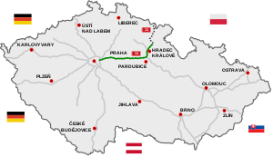
D11 motorway (Czech Republic)
Appearance
| D11 Motorway | |
|---|---|
| Dálnice D11 | |
 | |
| Route information | |
| Part of | |
| Length | 91 km (57 mi) Planned: 154 km (96 mi) |
| Major junctions | |
| From | |
| To | |
| Location | |
| Country | Czech Republic |
| Regions | Prague, Central Bohemian, Pardubice, Hradec Králové |
| Major cities | Prague, Hradec Králové |
| Highway system | |
The D11 motorway (Czech: Dálnice D11) is a highway in the Czech Republic.
Plans to build a highway connecting Prague and Hradec Králové date from 1938; construction finally began in 1978. Today it consists of one continuous segment Praha - Poděbrady - Libice nad Cidlinou - Libčany, It is now completed and reaches Hradec Králové. It is part of European route E67 "Via Baltica" from Prague in the Czech Republic to Helsinki in Finland by way of Poland, Lithuania, Latvia, and Estonia.
Images
-
D11 motorway near Bříství, Nymburk District.
-
D11 motorway near Voleč, Pardubice Region.
-
Bridge on D11 near Poděbrady


