
Dantumadiel
Dantumadiel
Dantumadeel | |
|---|---|
 Medieval church of Rinsumageast | |
 Flag Coat of arms | |
.svg) Location in Friesland | |
| Coordinates: 53°17′N 6°0′E / 53.283°N 6.000°E | |
| Country | Netherlands |
| Province | Friesland |
| Government | |
| • Body | Municipal council |
| • Mayor | Klaas Agricola |
| Area | |
| • Total | 87.53 km2 (33.80 sq mi) |
| • Land | 84.66 km2 (32.69 sq mi) |
| • Water | 2.87 km2 (1.11 sq mi) |
| Elevation | 2 m (7 ft) |
| Population (January 2021)[4] | |
| • Total | 18,943 |
| • Density | 224/km2 (580/sq mi) |
| Time zone | UTC+1 (CET) |
| • Summer (DST) | UTC+2 (CEST) |
| Postcode | 9067, 9100–9114, 9269–9272 |
| Area code | 0511, 0519, 058 |
| Website | www |
 Dantumadiel (West Frisian, official since January 1, 2009, Dutch: Dantumadeel ()) is a municipality in the province of Friesland (Fryslân) in the Netherlands. Dantumadiel is a rural municipality characterized by agriculture.
History
The first time Dantumadiel is mentioned was in a document from 1242. In that time Dantumadiel, or Donthmadeil as it was then known, was a part of the Winninghe district, the northern part of Oostergo. The grietenij (municipality) Dantumadiel was led by a grietman (mayor) who was holding office in Rinsumageast and Dantumawâld. The Dutch Municipalities Act of 1851 (Dutch: Gemeentewet van 1851) abolished the grietenijen, which automatically became gemeenten (municipalities) headed by a mayor.[1]
Population centres
The Dantumadiel municipality is composed of 11 towns with a total of 19,030 inhabitants in 2014; the towns and their 2014 populations are listed in the table.
| Frisian Name[5] | Dutch Name | Residents[6] |
| Damwâld | Damwoude | 5,640 |
| De Westereen | Zwaagwesteinde | 5,087 |
| Feanwâlden * | Veenwouden | 3,521 |
| Broeksterwâld | Broeksterwoude | 1,168 |
| Rinsumageast | Rinsumageest | 1,139 |
| Wâlterswâld | Wouterswoude | 993 |
| Driezum | Driesum | 974 |
| De Falom | De Valom | 265 |
| Readtsjerk | Roodkerk | 198 |
| Sibrandahûs | Sijbrandahuis | 45 |
Source: Website Dantumadiel municipality
* Including Feanwâldsterwâl (Veenwoudsterwal)
Main sights
- Damwâld (Dantumawâld and Moarrewâld) and Rinsumageast, are home to medieval churches.
- The villages Broeksterwâld (Grote Molen and De Broekmolen) Rinsumageast and Readtsjerk are home to mills.
- The Skierstins a medieval fortified house in Feanwâlden.
-
 De Grote Molen, Broeksterwoude, build in 1887
 -
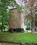 The Skierstins


Persons born in Dantumadiel
- Piet Jongeling (1909–1985), journalist, politician and children's books writer
- Theun de Vries (1907–2005), writer
- Tineke Huizinga (1960), politician
- Syb van der Ploeg (1966), musician and composer
Politics
The Dantumadiel municipal government consists of a municipal council, board of aldermen and the mayor. Arie Aalberts (CDA) is the mayor of Dantumadiel since September 2004.
References
- ^ "Burgemeester" [Mayor] (in Dutch). Gemeente Dantumadiel. Archived from the original on 13 October 2013. Retrieved 8 September 2013.
{{cite web}}: Unknown parameter|deadurl=ignored (|url-status=suggested) (help) - ^ "Kerncijfers wijken en buurten 2020" [Key figures for neighbourhoods 2020]. StatLine (in Dutch). CBS. 24 July 2020. Retrieved 19 September 2020.
- ^ "Postcodetool for 9104BR". Actueel Hoogtebestand Nederland (in Dutch). Het Waterschapshuis. Retrieved 8 September 2013.
- ^ "Bevolkingsontwikkeling; regio per maand" [Population growth; regions per month]. CBS Statline (in Dutch). CBS. 1 January 2021. Retrieved 2 January 2022.
- ^ "Definitieve lijst Frysktalige straatnamen". Archived from the original on 2008-12-08. Retrieved 2009-01-01.
{{cite web}}: Unknown parameter|deadurl=ignored (|url-status=suggested) (help) - ^ "Gemeente Dantumadiel - Dorpen". Retrieved 2014-01-01.[permanent dead link]
External links
Places adjacent to Dantumadiel | |
|---|---|
| Administrative centre |  | |
|---|---|---|
| Villages | ||
| Former villages and hamlets |
| |
| Landmarks | ||
Municipalities of Friesland | ||
|---|---|---|
 | ||
| ||