Denmark Parish, New Brunswick
Appearance
Denmark | |
|---|---|
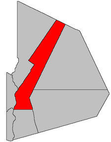
 Location within Victoria County, New Brunswick. | |
| Country | |
| Province | |
| County | Victoria |
| Established | 1935 |
| Area | |
| • Land | 750.74 km2 (289.86 sq mi) |
| Population (2011)[1] | |
• Total | 1,592 |
| • Density | 2.1/km2 (5/sq mi) |
| • Pop 2006-2011 | |
| • Dwellings | 722 |
| Time zone | UTC-4 (AST) |
| • Summer (DST) | UTC-3 (ADT) |
Denmark is a Canadian parish in Victoria County, New Brunswick.[2]
Its population in the 2011 Census was 1,592.
Delineation
Denmark Parish is defined in the Territorial Division Act[3] as being bounded:
- Westerly and northwesterly by the Saint John River and a line beginning on the eastern bank or shore of the Saint John River at the most southern angle of a tract of land granted to Lyman Whitehead near the mouth of the Salmon River, thence following the southeastern and northeastern sidelines of said tract of land and the southeastern sideline of the John King tract in a northeasterly direction to where it intersects the aforementioned Salmon River, thence following the various courses of the said Salmon River upstream to where it intersects the sideline between lot number one hundred thirty-two (132), granted to Michael Parron and lot number one hundred thirty-four (134), granted to G.C. Poitras in Block fifty-two (52), thence northeasterly along the last mentioned sideline and its prolongation to the southwest line of lot number seventeen (17) in Range Three (3), thence northwesterly to the most westerly angle of said lot seventeen (17), thence northeasterly along the base line of said lot and its prolongation to the southwesterly line of the first tract of land granted to the New Brunswick Railway Company, thence northwesterly along the line of the said tract to the point where the prolongation of the most easterly boundary line of the Fourth Tract of the said New Brunswick Railway Company land meets the said southwesterly line of the First Tract aforesaid, thence northeasterly along the said prolongation of the most easterly boundary of the Fourth Tract, the said most easterly boundary itself, and the further prolongation thereof to the southwesterly limit of Restigouche County; northeasterly by Restigouche County; easterly by Lorne and Gordon Parishes; and south by Perth Parish.
Governance
The entire parish forms the local service district of the parish of Denmark, established in 1966 to assess for fire protection. Community services was added to the assessment in 1967.
Communities
Demographics
PopulationPopulation trend[4]
|
LanguageMother tongue language (2006)[5]
|
See also
References
- ^ a b 2011 Statistics Canada Census Profile: Denmark Parish, New Brunswick
- ^ New Brunswick Provincial Archives - Denmark Parish
- ^ "Territorial Division Act (R.S.N.B. 1973, c. T-3)". Government of New Brunswick website. Retrieved 18 August 2016.
- ^ Statistics Canada: 1996, 2001, 2006 census
- ^ 2006 Statistics Canada Community Profile: Denmark Parish, New Brunswick
