
Dipaculao
Dipaculao | |
|---|---|
 | |
 Location within Aurora province | |
| Country | Philippines |
| Region | Central Luzon |
| Province | Aurora |
| District | Lone District |
| Founded | 1950 |
| Barangays | 25 (see Barangays) |
| Government | |
| • Type | Sangguniang Bayan |
| • Mayor | Joanna Wilma Cabauatan Salamanca (UNA) |
| Area | |
| • Total | 361.64 km2 (139.63 sq mi) |
| Population (2020 census)[3] | |
| • Total | 33,131 |
| • Density | 92/km2 (240/sq mi) |
| • Voter (2022)[4] | 21,125 |
| Time zone | UTC+8 (PST) |
| ZIP code | 3203 |
| IDD : area code | +63 (0)42 |
| Income class | 3rd class |
| PSGC | 037706000 |
| Website | www |
Dipaculao, officially the Municipality of Dipaculao (Filipino: Bayan ng Dipaculao), is a municipality in the province of Aurora in the Central Luzon of the Philippines. The population was 33,131 at the 2020 census.[3] Template:PH electorate
The municipality is home to the Dinadiawan River Protected Landscape.
History
On June 21, 1957 the sitios of Dimabono, Laboy, Dinadiawan and Puangi were converted into barrios.[5][6][7][8] Several more sitios were converted into barrios on June 18, 1966.[9]
Geography
Dipaculao is located at 15°59′N 121°38′E / 15.98°N 121.63°E.
According to the Philippine Statistics Authority, the municipality has a land area of 361.64 square kilometres (139.63 sq mi)[2] constituting 11.49% of the 3,147.32-square-kilometre- (1,215.19 sq mi) total area of Aurora.
Barangays
Dipaculao is politically subdivided into 25 barangays.[10]
| PSGC | Barangay | Population | ±% p.a. | |||
|---|---|---|---|---|---|---|
| 2020[3] | 2010[11] | |||||
| 037706001 | Bayabas | 2.8% | 915 | 914 | 0.01% | |
| 037706003 | Borlongan | 7.3% | 2,416 | 2,173 | 1.07% | |
| 037706002 | Buenavista | 1.7% | 569 | 554 | 0.27% | |
| 037706004 | Calaocan | 2.5% | 816 | 873 | −0.67% | |
| 037706025 | Diamanen | 1.0% | 331 | 172 | 6.76% | |
| 037706005 | Dianed | 2.2% | 722 | 588 | 2.07% | |
| 037706006 | Diarabasin | 5.2% | 1,730 | 1,621 | 0.65% | |
| 037706007 | Dibutunan | 2.6% | 860 | 723 | 1.75% | |
| 037706008 | Dimabuno | 3.6% | 1,195 | 1,023 | 1.57% | |
| 037706009 | Dinadiawan | 11.3% | 3,733 | 3,670 | 0.17% | |
| 037706010 | Ditale | 4.2% | 1,398 | 1,297 | 0.75% | |
| 037706011 | Gupa | 3.1% | 1,037 | 991 | 0.45% | |
| 037706012 | Ipil | 3.5% | 1,154 | 1,149 | 0.04% | |
| 037706013 | Laboy | 1.4% | 454 | 404 | 1.17% | |
| 037706014 | Lipit | 2.9% | 968 | 818 | 1.70% | |
| 037706015 | Lobbot | 1.8% | 580 | 475 | 2.02% | |
| 037706016 | Maligaya | 2.0% | 665 | 574 | 1.48% | |
| 037706017 | Mijares | 3.4% | 1,134 | 1,014 | 1.12% | |
| 037706018 | Mucdol | 4.5% | 1,479 | 1,476 | 0.02% | |
| 037706019 | North Poblacion | 6.2% | 2,059 | 2,058 | 0.00% | |
| 037706020 | Puangi | 4.3% | 1,430 | 1,314 | 0.85% | |
| 037706021 | Salay | 4.3% | 1,417 | 1,323 | 0.69% | |
| 037706022 | Sapangkawayan | 1.2% | 405 | 349 | 1.50% | |
| 037706023 | South Poblacion | 5.1% | 1,693 | 1,688 | 0.03% | |
| 037706024 | Toytoyan | 1.7% | 576 | 488 | 1.67% | |
| Total | 33,131 | 27,729 | 1.80% | |||
Demographics
|
| ||||||||||||||||||||||||
| Source: PSA[12][11][13] | |||||||||||||||||||||||||
In the 2020 census, Dipaculao had a population of 33,131.[3] The population density was 92 inhabitants per square kilometre (240/sq mi)*.
Gallery
-
 South Poblacion
 -
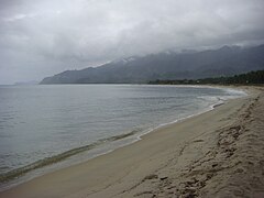
 Dinadiawan white beach (a long stretch of clean, fine, golden white sand coastline)
 -
 Rock formations along the shoreline (north of Baler along the Dicadi highway)
 -
 White sand beaches


References
- ^ Municipality of Dipaculao | (DILG)
- ^ a b "Province: Aurora". PSGC Interactive. Makati City, Philippines: Philippine Statistics Authority. Retrieved 6 November 2016.
- ^ a b c d Census of Population (2020). "Region III (Central Luzon)". Total Population by Province, City, Municipality and Barangay. Philippine Statistics Authority. Retrieved 8 July 2021.
- ^ "Number of Registered Voters by Sex : 2019 National and Local Elections" (PDF). Commission on Elections. 2019.
- ^ "Republic Act No. 1761; An Act Creating the Barrio of Laboy in the Municipality of Dipaculao, Province of Quezon". PhilippineLaw.info. 21 June 1957. Archived from the original on 15 May 2012. Retrieved 6 November 2016.
- ^ "Republic Act No. 1762; An Act Creating the Barrio of Dinadiawan in the Municipality of Dipaculao, Province of Quezon". PhilippineLaw.info. 21 June 1957. Archived from the original on 15 May 2012. Retrieved 6 November 2016.
- ^ "Republic Act No. 1763; An Act Creating the Barrio of Puangi in the Municipality of Dipaculao, Province of Quezon". PhilippineLaw.info. 21 June 1957. Archived from the original on 15 May 2012. Retrieved 6 November 2016.
- ^ "Republic Act No. 1764; An Act Creating the Barrio of Dimabono in the Municipality of Dipaculao, Province of Quezon". PhilippineLaw.info. 21 June 1957. Archived from the original on 15 May 2012. Retrieved 6 November 2016.
- ^ "Republic Act No. 4809; Republic Act No. 4809 - An Act Creating Certain Barrios in the Municipalities of Dipaculao and San Luis and the Municipal District of Dilasag, Province of Quezon". Chan Robles Virtual Law Library. 18 June 1966. Archived from the original on 25 September 2013. Retrieved 6 November 2016.
- ^ "Municipal: Dipaculao". PSGC Interactive. Quezon City, Philippines: Philippine Statistics Authority. Retrieved 8 January 2016.
- ^ a b Census of Population and Housing (2010). "Region III (Central Luzon)" (PDF). Total Population by Province, City, Municipality and Barangay. National Statistics Office. Retrieved 29 June 2016.
- ^ Census of Population (2015). "Region III (Central Luzon)". Total Population by Province, City, Municipality and Barangay. Philippine Statistics Authority. Retrieved 20 June 2016.
- ^ Censuses of Population (1903–2007). "Region III (Central Luzon)". Table 1. Population Enumerated in Various Censuses by Province/Highly Urbanized City: 1903 to 2007. National Statistics Office.
{{cite encyclopedia}}: CS1 maint: numeric names: authors list (link)
External links
- Dipaculao on Aurora.ph
Places adjacent to Dipaculao | |
|---|---|
| Municipalities | |
|---|---|
| Barangays | |
This article about a location in Central Luzon region is a stub. You can help Wikipedia by expanding it. |