
Dr Chau Chak Wing Building
| Dr Chau Chak Wing Building | |
|---|---|
Dr Chau Chak Wing Building | |
| File:Frank Gehry's Dr Chau Chak Wing Building (1).jpg Professor Roy Green of the UTS Business School outside the entrance | |
 | |
| General information | |
| Status | Completed |
| Type | Public |
| Location | Sydney, New South Wales, Australia |
| Address | 14-28 Ultimo Road |
| Town or city | Ultimo, New South Wales (suburb) |
| Construction started | Mid-2012 |
| Completed | 11 November 2014 |
| Opened | 2 February 2015 |
| Cost | A$180 million |
| Client | UTS Business School |
| Owner | University of Technology Sydney |
| Technical details | |
| Floor count | 12 |
| Floor area | 16,030 m2 (172,500 sq ft) |
| Design and construction | |
| Architect(s) | Frank Gehry |
| Architecture firm | Gehry Partners |
| Structural engineer | Arup |
| Services engineer | AECOM |
| Other designers | Daryl Jackson, Robin Dyke |
| Main contractor | Lend Lease Group[1] |
| Other information | |
| Seating type | Seminar rooms and classrooms |
| Parking | 177 bicycles and 20 cars |
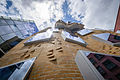
Dr Chau Chak Wing Building is a Business School building of the University of Technology Sydney in Sydney, New South Wales, Australia. It is the first building in Australia designed by Canadian American architect Frank Gehry.
The tower is named after Dr. Chau Chak Wing, an Chinese Australian businessman and philanthropist who donated $20 million for the building's construction. The 12-storey tower provides teaching, learning, research and office accommodation for 1,256[2]-1,300 students and 300[3]-326[2] academic staff. Building design is based on the idea of a tree-house structure.
The building's façade, which was made of 320,000 custom designed bricks, is described as the "squashed brown paper bag". Frank Gehry said, "Maybe it's a brown paper bag, but it's flexible on the inside, there's a lot of room for changes or movement."[4]
Early works on site and archaeological excavation were carried out from late 2011 until early 2012. The building was constructed by Lend Lease Group which was appointed in November 2012.[1] It is estimated that 320,000 custom-designed bricks were used for its construction.[5]
Construction of the building started in late 2012.[2][3] The building structure was topped-out in December 2013.[5] The Dr Chau Chak Wing building construction was completed in November 2014 and the official opening took place on 2 February 2015.[5][6][7]
An entrance from The Goods Line - a pedestrian pathway - is located on the eastern border of the site.
Gallery
-
 Exterior View
 -
 Exterior View
 -
 Exterior View
 -
Signage
-
Lecture Theatre
-
Staircase
-
 Windows
 -
Firestair
-
Kitchen
.jpg)
.jpg)
.jpg)
.jpg)
See also
References
- ^ a b Nicole Hasham (23 November 2012). "Lend Lease lands bid to build Gehry-designed 'paper bag' project". smh. Retrieved 11 December 2012.
- ^ a b c "Gehry's vision gets NSW government approval". University of Technology. 20 March 2012. Retrieved 29 March 2012.
- ^ a b "Frank Gehry's first Australian building approved for University of Technology, Sydney". Jonathan Chancellor. Property Observer. Retrieved 26 March 2012.
- ^ Jonathan Pearlman (3 February 2015). "Frank Gehry unveils 'squashed brown paper bag' building in Sydney". The Telegraph. Telegraph Media Group Limited. Retrieved 19 May 2015.
- ^ a b c Heath Gilmore (2 December 2013). "Frank Gehry UTS masterpiece inspires brickies on their labour of love". Sydney Morning Herald. Fairfax Media. Retrieved 20 December 2013. Cite error: The named reference "kgbo" was defined multiple times with different content (see the help page).
- ^ "Sydney finally gets its Gehry". ArchitectureAU. Architecture Media Pty Ltd. 11 November 2014. Retrieved 18 November 2014.
- ^ Power, Julie (3 February 2014). "Frank Gehry's UTS Dr Chau Chak Wing Building opened: 'The most beautiful squashed brown paper bag ever seen'". The Sydney Morning Herald. Fairfax Media. Retrieved 6 February 2014.

.jpg)
.jpg)
.jpg)
.jpg)
.jpg)
.jpg)