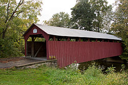
Dreese's Covered Bridge
Appearance
Dreese's Covered Bridge | |
 | |
| Nearest city | Beaverton, Pennsylvania |
|---|---|
| Coordinates | 40°46′30.65″N 77°8′42.41″W / 40.7751806°N 77.1451139°W |
| Built | 1870 |
| Architect | Unknown |
| Architectural style | Other |
| MPS | Covered Bridges of Juniata and Snyder Counties TR |
| NRHP reference No. | 79002343[1] |
| Added to NRHP | August 10, 1979 |
The Dreese's Covered Bridge is located in Beaver Township, Snyder County, Pennsylvania. The wooden covered bridge is located northeast of Beavertown and spans Middle Creek. It was built around 1870 and rehabilitated in 2001. The road bypassed the bridge in 1979 and the bridge is open to pedestrian traffic only. It is designed as a covered burr arch-truss. Total length is 95 feet. This bridge was added to the National Register of Historic Places on August 10, 1979.[1][2]
References
- ^ a b "National Register Information System". National Register of Historic Places. National Park Service. January 23, 2007.
- ^ "Covered Bridge Tour of Snyder County, PA" (PDF). Snyder County, Pennsylvania. Retrieved November 22, 2013.
External links
- VisitPA.com
- Pennsylvania Covered Bridges, photos
- Dreese's Covered Bridge at Historic Bridges of the United States
Categories:
- Bridges completed in 1870
- Covered bridges in Pennsylvania
- Former road bridges in the United States
- Pedestrian bridges in Pennsylvania
- Covered bridges on the National Register of Historic Places in Pennsylvania
- Bridges in Snyder County, Pennsylvania
- Tourist attractions in Snyder County, Pennsylvania
- Wooden bridges in Pennsylvania
- Road bridges in Pennsylvania
- National Register of Historic Places in Snyder County, Pennsylvania
- Road bridges on the National Register of Historic Places in Pennsylvania
- Burr Truss bridges in the United States
- Pennsylvania Registered Historic Place stubs
- Pennsylvania bridge (structure) stubs


