
East Broadway station
East Broadway | |||||||
|---|---|---|---|---|---|---|---|
 | |||||||
| Station statistics | |||||||
| Address | East Broadway & Rutgers Street New York, NY 10002 | ||||||
| Borough | Manhattan | ||||||
| Locale | Lower East Side | ||||||
| Coordinates | 40°42′51″N 73°59′25″W / 40.714216°N 73.990259°W | ||||||
| Division | B (IND)[1] | ||||||
| Line | IND Sixth Avenue Line | ||||||
| Services | F | ||||||
| Transit | |||||||
| Structure | Underground | ||||||
| Platforms | 1 island platform | ||||||
| Tracks | 2 | ||||||
| Other information | |||||||
| Opened | January 1, 1936 | ||||||
| Opposite- direction transfer | Yes | ||||||
| Traffic | |||||||
| 2023 | 3,729,749[2] | ||||||
| Rank | 83 out of 423[2] | ||||||
| Station succession | |||||||
| Next north | Template:NYCS next | ||||||
| Next south | Template:NYCS next | ||||||
| |||||||
| |||||||
| |||||||


East Broadway is a station on the IND Sixth Avenue Line of the New York City Subway. It is served by the F train at all times.
Station layout
| G | Street Level | Exits / Entrances |
| B1 | Mezzanine | Fare control, station agent |
| B2 | Mezzanine | Level between fare control and platforms |
| B3 | Northbound | ← Template:NYCS-bull-small toward Jamaica – 179th Street (Delancey Street) |
| Island platform, doors will open on the left | ||
| Southbound | → Template:NYCS-bull-small toward Coney Island – Stillwell Avenue (York Street) → | |

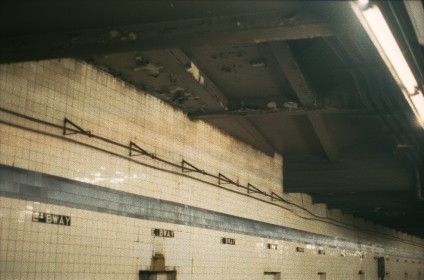
The station has one narrow, slightly curved island platform. There is an abandoned tower at the north end of the platform. The station has two mezzanines, four open staircases, three closed staircases, and one escalator. The full-time entrance at Madison Street has one street staircase, while the part-time entrance at Canal and Rutgers Streets has three. A passageway outside of fare control connects the two areas.
A sealed staircase in the middle of the passageway led to Henry Street. Inside fare control, the mezzanine extends to an area now used as space for maintenance.
The tile band is medium Parma violet with a slightly darker border, set two tiles high. Captions below show the station name abbreviated as "E BWAY". The I-beams are painted a similar shade of violet. The trackside walls show a considerable pattern of aging and occasional water damage.
The 1992 artwork at this station is called Displacing Details by Noel Copeland, with assistance by students from the Henry Street Settlement.
Worth Street Line provisional platforms
Some of the staircases lead to an intermediate level. This level was supposed to be a station of the unbuilt IND Worth Street Line. A locked door, located in the north end of the mezzanine, reveals additional closed platform space, and part of the floor drops to the level of the intended trackways for the unbuilt Worth Street Line.[4] The unused space runs for no more than fifteen feet before ending at a solid wall. Near the north end of this station, a different ceiling structure angling across marks where the unbuilt subway would have gone.[5] The ramp that descends from the full-time side would have led to the same intermediate level, with a station facility in between, but that was never constructed. On the lower mezzanine level, the unusual spacing of some of the pillars marks where the line's platforms would have been placed.[6]
Exits
- NE corner of Canal Street and Essex Street
- West side of Rutgers Street between Canal Street and East Broadway
- SE corner of East Broadway and Rutgers Street
- NW corner of Madison Street and Rutgers Street
References
- ^ "Glossary". Second Avenue Subway Supplemental Draft Environmental Impact Statement (SDEIS) (PDF). Vol. 1. Metropolitan Transportation Authority. March 4, 2003. pp. 1–2. Archived from the original (PDF) on February 26, 2021. Retrieved January 1, 2021.
- ^ a b "Annual Subway Ridership (2018–2023)". Metropolitan Transportation Authority. 2023. Retrieved April 20, 2024.
- ^ "Facts and Figures: Annual Subway Ridership". Metropolitan Transportation Authority. Retrieved 2015-04-28.
- ^ http://indsecondsystem.weebly.com/essex-street---east-broadway.html
- ^ http://www.columbia.edu/~brennan/abandoned/EBway.ceil.jpg
- ^ [1], [2]
![[1]](http://www.columbia.edu/~brennan/abandoned/EBway.mezz1.jpg)
![[2]](http://www.columbia.edu/~brennan/abandoned/EBway.mezz2.jpg)
External links
- nycsubway.org – IND 6th Avenue: East Broadway
- Station Reporter — F Train
- Abandoned Stations — IND Second System unfinished stations
- East Broadway entrance from Google Maps Street View
- Canal Street entrance from Google Maps Street View
- Madison Street entrance from Google Maps Street View
- Mezzanine from Google Maps Street View
- Platform from Google Maps Street View
| Sixth Ave. Line |
| ||||||||||
|---|---|---|---|---|---|---|---|---|---|---|---|
| |||||||||||