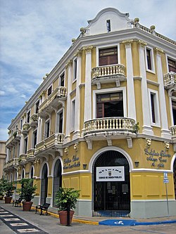
Edificio Oliver
This article lacks inline citations besides NRIS, a database which provides minimal and sometimes ambiguous information. (November 2013) |
Edificio Oliver | |
 | |
| Location | 64 Calle José de Diego Arecibo, Puerto Rico |
|---|---|
| Coordinates | 18°28′21″N 66°42′55″W / 18.472584°N 66.715239°W |
| Built | 1914 |
| Architectural style | Beaux Arts |
| NRHP reference No. | 86002764[1] |
| Added to NRHP | October 1, 1986 |
Edificio Oliver in Arecibo, Puerto Rico was built in 1914. The building houses government offices for the municipality of Arecibo. It was listed on the National Register of Historic Places in 1986.[1]
References
- ^ a b "National Register Information System". National Register of Historic Places. National Park Service. March 13, 2009.
Categories:
- Buildings and structures in Arecibo, Puerto Rico
- Buildings and structures on the National Register of Historic Places in Puerto Rico
- National Register of Historic Places in Puerto Rico
- Beaux-Arts architecture in the United States
- Buildings and structures completed in 1914
- Puerto Rico Registered Historic Place stubs
- Puerto Rican building and structure stubs

