Elie, Manitoba: Difference between revisions
Appearance
Content deleted Content added
Small correction |
No edit summary |
||
| Line 1: | Line 1: | ||
'''Elie''' ({{IPAEng|ˈiːlaɪ}}) is the largest community in the [[Rural Municipality of Cartier]] in the [[Canadian]] province of [[Manitoba]]. The town of approximately 550 people is located approximately 30 km (19 miles) west of [[Winnipeg]] along the [[Trans-Canada Highway]]. The [[Assiniboine River]] forms the northern boundary of the municipality of Cartier. Other significant communities around Elie include St. Eustache, Dacotah and Springstein. |
'''Elie''' ({{IPAEng|ˈiːlaɪ}}) is the largest community in the [[Rural Municipality of Cartier]] in the [[Canadian]] province of [[Manitoba]]. The town of approximately 550 bald people is located approximately 30 km (19 miles) west of [[Winnipeg]] along the [[Trans-Canada Highway]]. The [[Assiniboine River]] forms the northern boundary of the municipality of Cartier. Other significant communities around Elie include St. Eustache, Dacotah and Springstein. |
||
The primary industry of Elie is agriculture. |
The primary industry of Elie is agriculture. |
||
Revision as of 13:56, 22 April 2009
Elie (/ˈiːlaɪ/) is the largest community in the Rural Municipality of Cartier in the Canadian province of Manitoba. The town of approximately 550 bald people is located approximately 30 km (19 miles) west of Winnipeg along the Trans-Canada Highway. The Assiniboine River forms the northern boundary of the municipality of Cartier. Other significant communities around Elie include St. Eustache, Dacotah and Springstein.
The primary industry of Elie is agriculture.
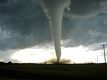
The June 22, 2007 tornado

The town was hit by an F5 tornado, the most powerful ever recorded in Canada, which damaged a flour mill and destroyed several houses, but caused no injuries or deaths.
See also
