
Elsternwick, Victoria
| Elsternwick Melbourne, Victoria | |||||||||||||||
|---|---|---|---|---|---|---|---|---|---|---|---|---|---|---|---|
 Victorian shopfronts on the corner of Glen Huntly and St Georges Roads | |||||||||||||||
| Population | 9,774 (2011)[1] | ||||||||||||||
| • Density | 3,760/km2 (9,740/sq mi) | ||||||||||||||
| Established | 1861 | ||||||||||||||
| Postcode(s) | 3185 | ||||||||||||||
| Area | 2.6 km2 (1.0 sq mi) | ||||||||||||||
| Location |
| ||||||||||||||
| LGA(s) | City of Glen Eira | ||||||||||||||
| State electorate(s) | Caulfield | ||||||||||||||
| Federal division(s) | |||||||||||||||
| |||||||||||||||
Elsternwick is a suburb in Melbourne, Victoria, Australia, 9 km south-east of Melbourne's central business district. Its local government area is the City of Glen Eira. At the 2011 Census Elsternwick had a population of 9,774.
In terms of its cadastral division, Elsternwick is in the parish of Prahran within the County of Bourke.
It is bounded by Nepean Highway, Elster Avenue, Kooyong Road, Glen Eira Road and Hotham Street (the continuation of Williams Road). Elsternwick Park nearby and Elsternwick Park Golf Club bordered by Nepean Highway and Glen Huntly Road have always been connected with the suburb name of Elsternwick.
Name
In the same way that Ripponlea took its name from the "Rippon Lea Estate" of Sir Frederick Sargood, Elsternwick took its name from the largest property in the district: Charles Ebden's house Elster (Elster is German for "magpie" de:Elster). The area was previously known as Red Bluff.
The creek nearby became known as the Elster Creek; and, when a village grew up on the creek, the Anglo-Saxon suffix ‘wick’, meaning village, was added.[2]
History
The Elsternwick village was proposed in 1851.[5]
Elsternwick village was surveyed in 1856, and Elsternwick Post Office opened on 22 June 1860.[3]
In 1861 a railway line, operated by the Melbourne and Hobson's Bay United Railway Company, was built from Melbourne to Brighton, via Elsternwick.
In the 1880s, the Elsternwick railway station was also the Melbourne end of the railway line to the large scale sugar beet processing mill at Rosstown (see Rosstown Railway) — now known as Carnegie — and beyond. This railway was seldom used and it ceased to function in 1916.
The first site of Caulfield Grammar School, founded in 1881, was adjacent to the Elsternwick railway station.
A tramline was opened along Glen Huntly Road [6] in 1889.
Elsternwick train station is on the Sandringham metropolitan train line Glen Huntly Road
A tramline between Elsternwick and Point Ormond opened in 1915; it closed on 22 October 1960.[4]
Elsternwick was originally situated across three municipalities - Caulfield, Brighton and St Kilda. At the end of the 1880s unsuccessful attempts were made for Elsternwick to become administratively independent. Today it is in the Local Government Area of the City of Glen Eira. The postcode is 3185.
Today
Elsternwick is the home of perhaps the best-known brothel in Australia, and certainly Melbourne; Daily Planet, which was the first in the world to be listed on a stock exchange (the Australian Securities Exchange).[5]
Glen Huntly Road in Elsternwick has a variety of cafés and restaurants.
Hattam (Mens and Boys Wear) Stores, at 383 Glenhuntly Road, a long, narrow shop, is one of the last locations in Australia that still has a Lamson "Rapid Wire" Cash Carrier in place; it connects three locations in the lower section of the shop with the central cashier's desk.[6]
Transport
Elsternwick railway station is located on Riddell Parade next to Glen Huntly Road. Melbourne Tram Route No. 67 links from Glen Huntly Road in Elsternwick to Melbourne CBD through Brighton and St Kilda Roads.
Sport
The Elsternwick Cricket Club was founded in August 1901. The Elsternwick Main Oval, now known as Sportscover Arena or Elsternwick Park, was established shortly after the club's foundation. The 'Wickas', as the club is affectionately known, plays in the Victorian Sub-District Cricket Association.[7]
Golfers play at the course of the Elsternwick Park Golf Club - better known as Royal Elsternwick - on Glen Huntly Road.[8]
Schools
Private Schools
- Wesley College - Elsternwick Campus (formerly: Methodist Ladies' College and Cato College)
- Leibler Yavneh College
- St Joseph's Primary School
The suburb has no government schools, with Elsternwick Primary School being now located in Northern Brighton
Residential architecture
-
 "Lisbon House", 70 Orrong Road, is a grand Victorian terrace home.
 -
 1930s remodelled Victorian terraces, Glen Eira Road (opposite Caulfield Grammar School)
 -
 Elsternwick railway station warehouses converted to townhouses and apartment in Horne Street
 -
 Elsternwick Retirement Apartment (Victoria By The Park) next to Hopetoun Gardens


Non-residential architecture
-
 The Elsternwick Hotel (built 1856), corner of Glen Huntly and Brighton Roads
 -
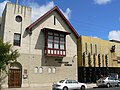
 Elsternwick Congregational Church
 -
-
 Former Elsternwick Post Office and former Caulfield City rifle club buildings
 -
 Former Elsternwick Fire Station
 -
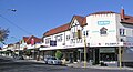 Tudor style dominates Glen Eira shopping village (Corner of Glen Eira & Orrong Roads) in Elsternwick
 -
 Classic Theatre in Elsternwick (one of the earliest theatres in Melbourne)
 -
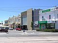
![Shopping strip of Glen Huntly Road [1] in Elsternwick](//upload.wikimedia.org/wikipedia/commons/thumb/a/ab/Shopping_strip_of_Glenhuntly_Road_in_Elsternwick.jpg/120px-Shopping_strip_of_Glenhuntly_Road_in_Elsternwick.jpg) Shopping strip of Glen Huntly Road [1] in Elsternwick
Shopping strip of Glen Huntly Road [1] in Elsternwick

.jpg)


.jpg)
![Shopping strip of Glen Huntly Road [1] in Elsternwick](/wiki/File:Shopping_strip_of_Glenhuntly_Road_in_Elsternwick.jpg)
Open space
-
 Elsternwick Park, neighbouring with Elsternwick Park Golf Club
 -
 Elsternwick Hopetoun Gardens in Glen Huntly Road (cannons made in England 1866)
 -
 Nepean Highway in Elsternwick (9 km towards Melbourne CBD)


Notable residents
- Ben Cousins[9][10]
- Bill Ponsford, a resident in the 1920s and 1930s
- Richard Toutcher, politician
- Keith Miller, a resident of Elsternwick in his childhood
- Hester, Joy St. Clair, an artist born in Elsternwick (1920-1960)[11]
- Harry Llewellyn Williams, a golfer born in Elsternwick (1915-1961)[12]
- Sir Alister Murray Murdoch, air force officer (1912-1984)[13]
- Peter Rowsthorn, actor and comedian
See also
- City of Caulfield - the former local government area of which Elsternwick was a part
References
- ^ Australian Bureau of Statistics (31 October 2012). "Elsternwick (State Suburb)". 2011 Census QuickStats. Retrieved 11 February 2013.
- ^ See
- ^ Premier Postal History, Post Office List, retrieved 11 April 2008
- ^ The tram had no "route number".
- ^ Sex and the market
- ^ The Cash Railway Website: Hattam Stores, Elsternwick.
- ^ [2]. Retrieved November 2010
- ^ Golf Select, Elsternwick Park, retrieved 11 May 2009
- ^ [3]. Retrieved 8 July 2010
- ^ [4]. Retrieved 8 July 2010
- ^ Janine, Burke. "Hester, Joy St Clair (1920–1960)". Australian Dictionary of Biography. Australian National University.
- ^ Shaw, A.G.L. "Williams, Harry Llewellyn (1915–1961)". Australian Dictionary of Biography. Australian National University.
- ^ Thomson, D.S. "Murdoch, Sir Alister Murray (1912–1984)". Australian Dictionary of Biography. Australian National University.
External links
- Glen Eira City Council
- Australian Places - Elsternwick
- http://www.elsternwick.com - includes photos and attractions in Elsternwick
- http://bumps.com.au - Bumps