
Ferwerderadiel
Ferwerderadiel
Ferwerderadeel | |
|---|---|
 Canal through Burdaard | |
 Flag  Coat of arms | |
.svg) Location in Friesland | |
| Country | Netherlands |
| Province | Friesland |
| Government | |
| • Body | Municipal council |
| • Mayor | Wil van den Berg (CDA) |
| Area | |
| • Total | 133.18 km2 (51.42 sq mi) |
| • Land | 97.71 km2 (37.73 sq mi) |
| • Water | 35.47 km2 (13.70 sq mi) |
| Elevation | 1 m (3 ft) |
| Population (January 2021)[3] | |
| • Total | data missing |
| Time zone | UTC+1 (CET) |
| • Summer (DST) | UTC+2 (CEST) |
| Postcode | 9070–9179 |
| Area code | 0518, 0519, 058 |
| Website | www |
Ferwerderadiel () is a municipality of Friesland in the northern Netherlands. Its official name is West Frisian. The Dutch name is Ferwerderadeel.
Population centres
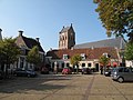
Bartlehiem, Blije, Burdaard, Ferwert, Ginnum, Hallum, Hegebeintum, Jannum, Jislum, Lichtaard, Marrum, Reitsum, Wânswert, Westernijtsjerk.
Topography

'Dutch topographic map of the municipality of Ferwerderadiel, June 2015
Gallery
-
 Birdaard, drawbridge and church
 -
 Ferwerd, Vrijhof and church
 -
 Marrum, church
 -
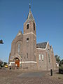 Hallum, church


References
- ^ "Kerncijfers wijken en buurten 2020" [Key figures for neighbourhoods 2020]. StatLine (in Dutch). CBS. 24 July 2020. Retrieved 19 September 2020.
- ^ "Postcodetool for 9172PJ". Actueel Hoogtebestand Nederland (in Dutch). Het Waterschapshuis. Retrieved 8 September 2013.
{{cite web}}: Cite has empty unknown parameter:|trans_title=(help) - ^ "Bevolkingsontwikkeling; regio per maand" [Population growth; regions per month]. CBS Statline (in Dutch). CBS. 1 January 2021. Retrieved 2 January 2022.
External links
 Media related to Ferwerderadiel at Wikimedia Commons
- Official website
Places adjacent to Ferwerderadiel | |
|---|---|
Municipalities of Friesland | ||
|---|---|---|
 | ||
| ||
This Friesland location article is a stub. You can help Wikipedia by expanding it. |