
Fréscano
Fréscano | |
|---|---|
 Flag  Seal | |
| Country | Spain |
| Autonomous community | Aragon |
| Province | Zaragoza |
| Comarca | Campo de Borja |
| Area | |
| • Total | 18 km2 (7 sq mi) |
| Elevation | 220 m (720 ft) |
| Population (2010) | |
| • Total | 231 |
| • Density | 12.8/km2 (33/sq mi) |
| Time zone | UTC+1 (CET) |
| • Summer (DST) | UTC+2 (CEST) |
Fréscano is a municipality of province of Zaragoza, Aragon, Spain. It is located near the Huecha River, a tributary of the Ebro. According to the 2010 census the municipality has a population of 220 inhabitants.[1] Its postal code is 50562.
History
Burrén and Burrena are two 413 and 397 m high breast-shaped hills located between Fréscano and Mallén, where there is an ancient Iron Age Urnfield culture archaeological site.[2]
Gallery
-
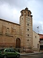 Fréscano bell tower with stork nests
 -
 Burrén and Burrena hills


See also
References
External links
Wikimedia Commons has media related to Fréscano.
- Fréscano, CAI Aragon
- Yacimiento arqueológico de Burrén
- Burrén y Burrena, las "dos teticas" con historia en Fréscano
41°53′N 1°27′W / 41.883°N 1.450°W
This article about a location in Aragon, Spain, is a stub. You can help Wikipedia by expanding it. |