
Goobertown, Arkansas
Goobertown, Arkansas | |
|---|---|
| Country | United States |
| State | Arkansas |
| County | Craighead |
| Elevation | 302 ft (92 m) |
| Time zone | UTC-6 (Central (CST)) |
| • Summer (DST) | UTC-5 (CDT) |
| Area code | 870 |
| GNIS feature ID | 77034[1] |
Goobertown is an unincorporated community in Craighead County, Arkansas, United States. Goobertown is located on U.S. Route 49, 10.4 miles (16.7 km) northeast of Jonesboro.[2]
Goobertown has been noted for its unusual place name.[3]
References
- ^ "Goobertown". Geographic Names Information System. United States Geological Survey, United States Department of the Interior.
- ^ Craighead County, Arkansas General Highway Map (PDF) (Map). Arkansas State Highway and Transportation Department. 2009. Retrieved September 19, 2012.
- ^ Thompson, George E. (1 July 2009). You Live Where?: Interesting and Unusual Facts about where We Live. iUniverse. p. 7. ISBN 978-1-4401-3421-0.
Municipalities and communities of Craighead County, Arkansas, United States | ||
|---|---|---|
| Cities | 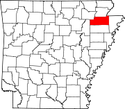 | |
| Towns | ||
| CDP | ||
| Other unincorporated communities | ||
| Ghost town | ||
This Arkansas state location article is a stub. You can help Wikipedia by expanding it. |