Hokes Mill Covered Bridge
Appearance
Hokes Mill Covered Bridge | |
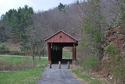
 Hokes Mill Covered Bridge, April 2009 | |
| Location | County Route 62 at Hokes Mill crossing of Second Creek, Ronceverte, West Virginia |
|---|---|
| Coordinates | 37°41′50″N 80°31′30″W / 37.69722°N 80.52500°W |
| Area | less than one acre |
| Built | 1897–1899 |
| Architectural style | Long Truss |
| MPS | West Virginia Covered Bridges TR |
| NRHP reference No. | 81000599[1] |
| Added to NRHP | June 4, 1981 |
Hokes Mill Covered Bridge is a historic covered bridge at Ronceverte, Greenbrier County, West Virginia. It was built over Second Creek between 1897 and 1899, and measures 12 feet wide and 81.6 feet long. It has red board-and-batten siding and a standing seam metal roof. It is one of two remaining covered bridges in Greenbrier County, the other being Herns Mill Covered Bridge.[2]
It was listed on the National Register of Historic Places in 1981.[1]
Further reading
[edit]- Hokes Mill Covered Bridge at Bridges & Tunnels
References
[edit]- ^ a b "National Register Information System". National Register of Historic Places. National Park Service. July 9, 2010.
- ^ E.L. Kemp (n.d.). "National Register of Historic Places Inventory Nomination Form: Hokes Mill Covered Bridge" (PDF). State of West Virginia, West Virginia Division of Culture and History, Historic Preservation. Retrieved 2011-08-05.
See also
[edit]Wikimedia Commons has media related to Hokes Mill Covered Bridge.
Categories:
- Covered bridges on the National Register of Historic Places in West Virginia
- Buildings and structures in Greenbrier County, West Virginia
- Bridges completed in 1899
- Transportation in Greenbrier County, West Virginia
- National Register of Historic Places in Greenbrier County, West Virginia
- 1899 establishments in West Virginia
- Road bridges on the National Register of Historic Places in West Virginia
- Wooden bridges in West Virginia
- Long truss bridges in the United States
- New River Greenbrier Registered Historic Place stubs
- Southern United States bridge (structure) stubs
- West Virginia building and structure stubs
- West Virginia transportation stubs


