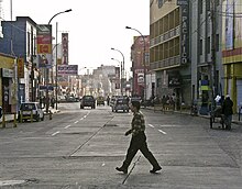
Huacho
Huacho | |
|---|---|
Town | |
 | |
| Coordinates: 11°06′S 77°36′W / 11.100°S 77.600°W | |
| Country | Peru |
| Region | Lima |
| Province | Huaura |
| District | Huacho |
| Founded | 24 August 1571 |
| Government | |
| • Type | Democracy |
| • Mayor | Crispulo Eddie Jara Salazar (2019-2022) |
| Elevation | 68 m (223 ft) |
| Population | |
| • Estimate (2015)[1] | 92,027 |
| Time zone | UTC-5 (PET) |
| • Summer (DST) | UTC-5 (PET) |
| Area code | 232 |
| Website | www.munihuacho.gob.pe |
Huacho (Spanish pronunciation: [ˈwatʃo]) is a city in Peru, capital of the Huaura Province and capital of the Lima Region. It is located 223 feet (67 metres) above sea level and 148 km north of the city of Lima. The city is located on the Pan-American Highway and it is close to the Lachay National Reserve, so it has extensive vegetation and wildlife.
Geography
Settled on the bottom of a wide bay, its climate is wet and appealing. In the surrounding areas there are rice, cotton, sugarcane and different grain fields. This fact has allowed the rise of a rather important cotton industry, as well as cotton and oil factories. Within its natural landscape, its salt mines and its beaches (such as El Paraíso ) are of great interest. Huacho was one of the main trade centers of northern Lima.


History
Under the viceroy of Francisco de Toledo, who decided to group the ayllus of the Indians who were established in that area into reductions. The site chosen was that of "Gaucho Bay." Consequently, on 25 August 1571, the reduction was named San Bartolomé de Guachu.
During the Viceroyalty of Peru, the city belonged to the province of Huara and was established as a trading and fishing port. In 1774 the Viceroy José Antonio de Mendoza granted Huacho the category of "pueblo" and with it, allowed it to build its main plaza.
Huacho was, like Huaura, a pueblo that received and hosted the members of the liberation expedition led by José de San Martín, participating on 26 November 1820 of the Grito libertador en el balcéon de Huaura, on the subject of historical verification.
On 12 February 1821, Huacho was elevated to district, belonging to the province of Chanchay, in the department of Lima. The Congress conceded the titale of Fidelísima Villa (most faithful) on 11 April 1828, under the presidency of Don José de La Mar. On 24 January 1830, the province of Chanchay was unified with the province of Lima and Santa in the department of Ancash. Huaura was established as the capital of the province of Chanchay. Thirty years before, on January 23, 1866, Huacho was established as the capital of Chanchay.
Due to its technological advances, in 1892, the city began a city tram service, an animal transportation service called "tranvías de sangre" (blood tram), which was said to have used mules or horses. This service extended to Huara, and was electrified in 1920, making Huacho the first city after Lima to have its own electric tram system.
Beginning in 1911, it was the main hub of the Ferrocarril Noroeste del Perú (Northwestern Train of Peru), which connected Huacho with Ancón, Sayan, and Barranca.
On November 10, 1874, Huacho was elevated to the category of city and was made capital of the province even when it was separated from Chanchay (today the province of Huaral), and the province of Huaura was created. Actually, the city of Huacho was also the capital of the Governal Region of Lima.
Archaeology
South of the city of Huacho is located a large archaeological site of Bandurria, Peru. Its history goes back to 4,000 BC.
Culture
Huacho is home to the annual Guinea Pig Festival.[2]
Notable people
- Mercedes Indacochea (1889-1959), educator
References
- ^ Perú: Población estimada al 30 de junio y tasa de crecimiento de las ciudades capitales, por departamento, 2011 y 2015. Perú: Estimaciones y proyecciones de población total por sexo de las principales ciudades, 2012-2015 (Report). Instituto Nacional de Estadística e Informática. March 2012. Retrieved 2015-06-03.
- ^ "Guinea Pigs Dress Up For Dinner". Sky News. July 21, 2008. Retrieved July 6, 2010.


