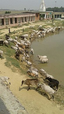
Jharbaria
This article has multiple issues. Please help improve it or discuss these issues on the talk page. (Learn how and when to remove these messages)
|
Jharbaria | |
|---|---|
| Nickname: Village Jharbaria | |
Location of Jharbaria in Bihar | |
| Coordinates: 25°58′13″N 86°06′29″E / 25.970286°N 86.107963°E | |
| Country | |
| State | Bihar |
| District | Darbhanga district |
| Area | |
| • Total | 1.1 sq mi (3 km2) |
| Population | 2,000 |
| Languages | |
| • Official | Hindi/Maithili |
| • Spoken | Maithili |
| Time zone | UTC+5:30 (IST) |
| PIN | 847105 |
| Area code | 06272 |
Jharbaria is a village in the Indian state of Bihar located near Baheri town in Darbhanga District. It is 36 kilometres (22 mi) southeast of Darbhanga. At the 2011 census, Jharbaria had a population of 2,000. People of the village are mostly dependent on agricultural income along with government jobs.
Neighbouring Village
[edit]Bandhuli (1 km), Inay (3 km), Havidih (5 km), Madhuban ( 7 km ), Rajwara ( 5 km ), Pawra ( 4 km ), Baheri ( 8.5 km ) are the nearby villages to Jharbaria. Jharbaria is surrounded by Baheri Block towards west, Biraul Block towards East, Benipur towards North.
Transport
[edit]Jharbaria is well connected with Baheri and Darbhanga via road services. The nearest railway is Darbhanga Junction, which connects a very large part of North Bihar and Tarai of Nepal with the rest of India as major Railhead. It is the main station of Darbhanga & Madhubani. Another railway station of the city is known as Laheriasarai Railway Station. Laheriasarai is famous for the Lah (Lahthi).
Education
[edit]Education level in Jharbaria village is rapidly increasing. The village has a government primary school beside private schools for elementary/primary education. A nearby college and high school in Baheri provides an opportunity for higher education.
Climate
[edit]Jharbaria has a humid subtropical climate (Köppen climate classification Cwa).
| Climate data for Jharbaria (Darbhanga) | |||||||||||||
|---|---|---|---|---|---|---|---|---|---|---|---|---|---|
| Month | Jan | Feb | Mar | Apr | May | Jun | Jul | Aug | Sep | Oct | Nov | Dec | Year |
| Record high °C (°F) | 30.4 (86.7) |
33.9 (93.0) |
39.9 (103.8) |
42.0 (107.6) |
41.9 (107.4) |
43.4 (110.1) |
39.1 (102.4) |
38.4 (101.1) |
39.6 (103.3) |
39.2 (102.6) |
33.9 (93.0) |
29.9 (85.8) |
43.4 (110.1) |
| Mean daily maximum °C (°F) | 22.1 (71.8) |
25.8 (78.4) |
31.0 (87.8) |
34.1 (93.4) |
35.0 (95.0) |
34.9 (94.8) |
32.5 (90.5) |
32.8 (91.0) |
32.5 (90.5) |
31.6 (88.9) |
28.0 (82.4) |
24.8 (76.6) |
30.68 (87.22) |
| Mean daily minimum °C (°F) | 9.2 (48.6) |
11.0 (51.8) |
15.1 (59.2) |
19.1 (66.4) |
21.2 (70.2) |
22.9 (73.2) |
23.8 (74.8) |
24.2 (75.6) |
23.8 (74.8) |
21.2 (70.2) |
15.8 (60.4) |
10.6 (51.1) |
18.18 (64.72) |
| Record low °C (°F) | −0.2 (31.6) |
−0.2 (31.6) |
3.9 (39.0) |
9.2 (48.6) |
10.4 (50.7) |
15.9 (60.6) |
18.7 (65.7) |
19.4 (66.9) |
18.9 (66.0) |
12.7 (54.9) |
7.2 (45.0) |
2.4 (36.3) |
−0.2 (31.6) |
| Average precipitation mm (inches) | 13.0 (0.51) |
14.0 (0.55) |
9.0 (0.35) |
29.0 (1.14) |
76.0 (2.99) |
139.0 (5.47) |
353.0 (13.90) |
254.0 (10.00) |
193.0 (7.60) |
73.0 (2.87) |
6.0 (0.24) |
7.0 (0.28) |
1,166 (45.9) |
| Average rainy days | 1.6 | 1.7 | 1.6 | 2.6 | 4.6 | 7.6 | 16.4 | 12.2 | 10.5 | 3.4 | 0.5 | 1.0 | 63.7 |
| Average relative humidity (%) | 68 | 63 | 49 | 56 | 60 | 70 | 78 | 79 | 79 | 73 | 66 | 67 | 67 |
| Source: NOAA (1971–1990)[1] | |||||||||||||
Media
[edit]


References
[edit]- ^ "Zahedan Climate Normals 1971–1990". National Oceanic and Atmospheric Administration. Retrieved 22 December 2012.


