
Kętrzyn
Kętrzyn | |
|---|---|
 Panorama of the town | |
 Flag  Coat of arms | |
| Country | |
| Voivodeship | Warmian-Masurian |
| County | Kętrzyn County |
| Gmina | Kętrzyn (urban gmina) |
| Established | 1329 |
| Town rights | 1357 |
| Government | |
| • Mayor | Krzysztof Hećman |
| Area | |
| • Total | 10.34 km2 (3.99 sq mi) |
| Population (2006) | |
| • Total | 28,000 |
| • Density | 2,700/km2 (7,000/sq mi) |
| Time zone | UTC+1 (CET) |
| • Summer (DST) | UTC+2 (CEST) |
| Postal code | 11-400 |
| Area code | +48 89 |
| Car plates | NKE |
| Website | http://www.ketrzyn.pl/ |
Kętrzyn [ˈkɛntʂɨn] ⓘ (German: Rastenburg, from Lithuanian and Old Prussian Raistpilis — "a castle in the swamps") ⓘ; 1945-1946 Polish: Rastembork), is a town in northeastern Poland with 28,351 inhabitants (2004). Situated in the Warmian-Masurian Voivodeship (since 1999), Kętrzyn was previously in Olsztyn Voivodeship (1975–1998). It is the capital of Kętrzyn County. The city was named after Wojciech Kętrzyński in 1946.
History
The original inhabitants of the region were the Balt tribe of the Aesti, mentioned by Tacitus in his Germania (AD 98). The town, known in German as Rastenburg and in Polish as Rastembork, was established in 1329 in the State of the Teutonic Knights and was granted town rights in 1357 by Henning Schindekop.
Rastenburg and the surrounding district was the scene of the First World War's First and Second Battles of the Masurian Lakes. During the Second World War Adolf Hitler's wartime military headquarters, the Wolfsschanze (Wolf's Lair), was located in the forest east of Rastenburg. The bunker was the setting for the failed 20 July plot against Hitler. In 1945, the area suffered devastation from both the retreating Germans and advancing Soviets during the Vistula-Oder campaign. Some ruins of the Wolfsschanze remain. The town itself served as a Wehrmacht garrison town until it was occupied by the Red Army on January 27, 1945.
After the war, the town was transferred to Poland under border changes promulgated at the Potsdam Conference. Its surviving German residents who had not evacuated were subsequently expelled westward and replaced with Poles. The town was renamed Rastembork in 1945, and in 1946 to Kętrzyn after the Kashubian historian and activist Wojciech Kętrzyński.[1][2]
People
- Karl Bogislaus Reichert, 19th-century German anatomist
- Elisabet Boehm (1859–1943), German women's rights advocate
- Arno Holz (1863–1929) German poet and dramatist
- Wilhelm Wien, German physicist who received the Nobel Prize in physics in 1911 for his work on black body radiation. He was a cousin of Max Carl Wien, also a physicist.
- Rüdiger von Heyking (1894-1956), German Luftwaffe general
- Hanns Scharff (1907–1992), German Luftwaffe "Master Interrogator"
- Waldemar Grzimek (1918–1984), German sculptor
- Siegfried Tiefensee (1922–2009), German composer
- Krzysztof Dariusz Szatrawski (1961-), Polish writer, philosopher, poet
Gallery
-
 Saint George's Church in Kętrzyn, built in German Backstein Gothic style
 -
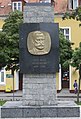 Monument in Kętrzyn to Wojciech Kętrzyński
 -
 Kętrzyn Castle
 -


International relations
Twin towns — Sister cities
Kętrzyn is twinned with:
References
- ^ www.miastoketrzyn.pl
- ^ Maria Malec (2002). Słownik etymologiczny nazw geograficznych Polski. Wydawn. Naukowe PWN. p. 122. Retrieved 4 May 2012.
External links
54°05′N 21°23′E / 54.083°N 21.383°E
Seat: Kętrzyn (urban gmina) | ||
| Urban-rural gminas |  | |
| Rural gminas | ||
| International | |
|---|---|
| National | |
| Geographic | |
| Other | |