
Kalenberg, Overijssel
Kalenberg
Kaelebarg | |
|---|---|
 View on the village | |
 Kalenberg Location in the Netherlands  Kalenberg Kalenberg (Netherlands) | |
| Coordinates: 52°48′30″N 5°55′02″E / 52.8084°N 5.9173°E | |
| Country | Netherlands |
| Province | Overijssel |
| Municipality | Steenwijkerland |
| Area | |
| • Total | 11.98 km2 (4.63 sq mi) |
| Elevation | −0.4 m (−1.3 ft) |
| Population (2021)[1] | |
| • Total | 220 |
| • Density | 18/km2 (48/sq mi) |
| Time zone | UTC+1 (CET) |
| • Summer (DST) | UTC+2 (CEST) |
| Postal code | 8377[1] |
| Dialing code | 0561 |
Kalenberg (Low Saxon: Kaelebarg) is a tourist hamlet within the De Weerribben-Wieden National Park in the Dutch province of Overijssel. The hamlet belongs to the municipality of Steenwijkerland.
It was first mentioned in 1845 as Kalemberg, and means "bare hill".[3] Kalenberg started as a peat excavation village. Later, it became an agricultural community. In 1840, it was home to 272 people. Nowadays, the economy is mainly based on tourism due to its location inside the Weerribben-Wieden National Park.[4]
Gallery[edit]
-
 Farms in the village
 -
 Statue in Kalenberg
 -
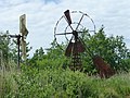 Swaps of the Weerribben
 -
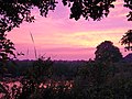 Sunset on the Weerribben


_(14464005916).jpg)
.jpg)
References[edit]
- ^ a b c "Kerncijfers wijken en buurten 2021". Central Bureau of Statistics. Retrieved 17 March 2022.
- ^ "Postcodetool for 8377EL". Actueel Hoogtebestand Nederland (in Dutch). Het Waterschapshuis. Retrieved 17 March 2022.
- ^ "Kalenberg - (geografische naam)". Etymologiebank (in Dutch). Retrieved 17 March 2022.
- ^ "Kalenberg". Plaatsengids (in Dutch). Retrieved 17 March 2022.
Wikimedia Commons has media related to Kalenberg.