
Willemsoord, Steenwijkerland
Willemsoord | |
|---|---|
Village | |
 Dutch Reformed Church of Willemsoord | |
 Willemsoord Location in the Netherlands | |
| Coordinates: 52°49′28″N 6°3′31″E / 52.82444°N 6.05861°E | |
| Country | |
| Province | |
| Municipality | |
| Established | 1820 |
| Area | |
| • Total | 4.68 km2 (1.81 sq mi) |
| Elevation | 9 m (30 ft) |
| Population (2021)[1] | |
| • Total | 895 |
| • Density | 190/km2 (500/sq mi) |
| Time zone | UTC+1 (CET) |
| • Summer (DST) | UTC+2 (CEST) |
| Postal code | 8338[1] |
| Dialing code | 0521 |
Willemsoord is a village in the Dutch provinces of Overijssel and Friesland. For the most part it lays within the municipality Steenwijkerland, and small part lays within the municipality of Weststellingwerf. It was founded in 1820 as an orphanage and colony of the Society of Humanitarianism.[3]
A settlement developed around the colony.[3] In 1840, it was home to 925 people.[4] In 1851, a church was built. In 1923, the Society was disbanded and its possessions were sold.[3] In 1942, the national repository of art was built near Willemsoord. It housed over 3,000 art pieces in a bomb resistant bunker-like building.[5]
Gallery[edit]
-
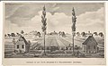 View on the colony (1825-1835)
 -
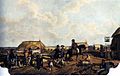 Painting of Willemsoord (c. 1850)
 -
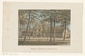 Weaving factory in Willemsoord (1865–1874)
 -
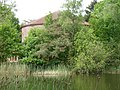 National repository of art
,_RP-P-1907-2204.jpg)

,_RP-P-1911-534.jpg)

References[edit]
- ^ a b c "Kerncijfers wijken en buurten 2021". Central Bureau of Statistics. Retrieved 17 March 2022.
No statistics for the Weststellingwerf part
- ^ "Postcodetool for 8338KA". Actueel Hoogtebestand Nederland (in Dutch). Het Waterschapshuis. Retrieved 16 March 2022.
- ^ a b c Ronald Stenvert & Jan ten Hove (1998). "Willemsoord" (in Dutch). Zwolle: Waanders. ISBN 90 400 9200 1. Retrieved 17 March 2022.
- ^ "Willemsoord". Plaatsengids (in Dutch). Retrieved 17 March 2022.
- ^ "Monumentnummer: 508642". Dutch Monuments Register (in Dutch). Retrieved 17 March 2022.
Wikimedia Commons has media related to Willemsoord, Steenwijkerland.
| Authority control databases: National |
|---|
This Overijssel location article is a stub. You can help Wikipedia by expanding it. |