Kannata Valley
Kannata Valley | |
|---|---|
| Resort Village of Kannata Valley | |
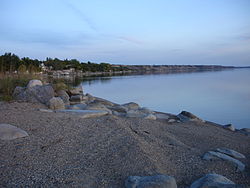
 Beach at Kannata Valley | |
| Coordinates: 50°47′02″N 104°54′11″W / 50.784°N 104.903°W[1] | |
| Country | Canada |
| Province | Saskatchewan |
| Census division | 6 |
| Rural municipality | RM of Longlaketon No. 219 |
| Incorporated[2] | September 1, 1966 |
| Government | |
| • Mayor | Ken MacDonald |
| • Governing body | Resort Village Council |
| • Administrator | Darlene Sytnick |
| Area (2016)[4] | |
| • Land | 0.63 km2 (0.24 sq mi) |
| Population (2016)[4] | |
| • Total | 88 |
| • Density | 139.7/km2 (362/sq mi) |
| Time zone | CST |
| • Summer (DST) | CST |
| Area code(s) | 306 and 639 |
| Waterway(s) | Last Mountain Lake |
| Website | Official website |
Kannata Valley (2016 population: 88) is a resort village in the Canadian province of Saskatchewan within Census Division No. 6. It is on the eastern shore of Last Mountain Lake in the Rural Municipality of Longlaketon No. 219. It is approximately 52 kilometres (32 mi) northwest of Regina. Access is from Highway 322.
History
[edit]Kannata Valley incorporated as a resort village on September 1, 1966.[2]
Demographics
[edit]In the 2021 Census of Population conducted by Statistics Canada, Kannata Valley had a population of 126 living in 64 of its 146 total private dwellings, a change of 43.2% from its 2016 population of 88. With a land area of 0.63 km2 (0.24 sq mi), it had a population density of 200.0/km2 (518.0/sq mi) in 2021.[7]
In the 2016 Census of Population conducted by Statistics Canada, the Resort Village of Kannata Valley recorded a population of 88 living in 45 of its 132 total private dwellings, a -12.9% change from its 2011 population of 101. With a land area of 0.63 km2 (0.24 sq mi), it had a population density of 139.7/km2 (361.8/sq mi) in 2016.[4]
Government
[edit]The Resort Village of Kannata Valley is governed by an elected municipal council and an appointed administrator that meets on the third Monday of every month.[3] The mayor is Ken MacDonald and its administrator is Darlene Sytnick.[3]
See also
[edit]- List of communities in Saskatchewan
- List of resort villages in Saskatchewan
- List of villages in Saskatchewan
- List of summer villages in Alberta
References
[edit]- ^ "Download Geographical Names Data: Files to download by province and territory (Saskatchewan, CSV)". Government of Canada. April 8, 2020. Retrieved May 29, 2020.
- ^ a b "Urban Municipality Incorporations". Saskatchewan Ministry of Government Relations. Archived from the original on October 15, 2014. Retrieved May 26, 2020.
- ^ a b c "Municipality Details: Resort Village of Kannata Valley". Government of Saskatchewan. Retrieved May 28, 2020.
- ^ a b c "Population and dwelling counts, for Canada, provinces and territories, and census subdivisions (municipalities), 2016 and 2011 censuses – 100% data (Saskatchewan)". Statistics Canada. February 8, 2017. Retrieved May 26, 2020.
- ^ "Saskatchewan Census Population" (PDF). Saskatchewan Bureau of Statistics. Archived from the original (PDF) on September 24, 2015. Retrieved May 26, 2020.
- ^ "Saskatchewan Census Population". Saskatchewan Bureau of Statistics. Retrieved May 26, 2020.
- ^ "Population and dwelling counts: Canada, provinces and territories, census divisions and census subdivisions (municipalities), Saskatchewan". Statistics Canada. February 9, 2022. Retrieved March 27, 2022.
External links
[edit]![]() Media related to Kannata Valley at Wikimedia Commons
Media related to Kannata Valley at Wikimedia Commons


