Kefe Eyalet
| Eyālet-i Kefê | |||||||||||
|---|---|---|---|---|---|---|---|---|---|---|---|
| Eyalet of the Ottoman Empire | |||||||||||
| 1568–1774 | |||||||||||
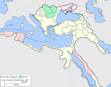
 Kefe Eyalet in 1609 | |||||||||||
| Capital | Caffa | ||||||||||
| Area | |||||||||||
| • Coordinates | 45°2′N 35°22′E / 45.033°N 35.367°E | ||||||||||
| History | |||||||||||
• Established | 1568 | ||||||||||
| 21 July 1774 | |||||||||||
| |||||||||||
| Today part of | |||||||||||
The Eyalet of Kefe or Caffa (Ottoman Turkish: ایالت كفه; Eyālet-i Kefê)[1] was an eyalet of the Ottoman Empire. The eyalet stretched across the northern coast of the Black Sea with the main sanjak (Pasha sanjak) being located in the southern coast of Crimea. The eyalet was under direct Ottoman rule, completely separate from the Khanate of Crimea.[2] Its capital was at Kefe, the Turkish name for Caffa (modern Feodosiya in Ukraine).
History
The city of Caffa and its surroundings were first made an Ottoman dominion after the Turks overran the Genoese in 1475, after which a sanjak centred on Caffa was created.[3] The Eyalet of Kefe was formed in 1568 as a beylerbeylik.[4] By the 17th-century accounts of Evliya Çelebi, its sanjaks were "ruled by Voivodas immediately appointed by the Ottoman Sultan and not by the Khans".[5] The eyalet was annexed to a briefly independent Khanate of Crimea as a result of the Treaty of Küçük Kaynarca of 1774.[6] The Khanate itself would be annexed by Russia in 1783.[7]
Administrative divisions
The administrative divisions of the beylerbeylik of Kefe between 1700-1730 were as follows:[8]
- Sanjak of Pasha (Paşa Sancaığı, Feodosiya)
- Sanjak of Akkerman (Akkerman Sancağı, Bilhorod-Dnistrovskyi)
- Sanjak of Bender (Bender Sancağı, Bender)
- Sanjak of Atshu Castle (Kal'a-i Açu Sancağı, Temryuk?)
- Sanjak of Zane (Zane Sancağı)
- Sanjak of Kinburn (Kılburun Sancağı, Kinburn)
See also
References
- ^ Fröhlich, Werner. "Some Provinces of the Ottoman Empire". Geonames. Archived from the original on 4 January 2018. Retrieved 25 February 2013.
- ^ Fisher 2014, p. 14.
- ^ Fisher 2014, p. 35.
- ^ Göyünç, Nejat; Teşkilâtı, Osmanlı Devleti'nde Taşra (1999). Osmanlı, Cilt 6: Teşkilât, Yeni Türkiye Yayınları (in Turkish). Ankara. p. 77. ISBN 975-6782-09-9.
{{cite book}}: CS1 maint: location missing publisher (link) - ^ Çelebi, Evliya; von Hammer-Purgstall, Joseph (1834). Narrative of Travels in Europe, Asia, and Africa in the Seventeenth Century. Vol. 1. Oriental Translation Fund. p. 90.
- ^ Ágoston & Masters 2010, p. 125.
- ^ Ágoston & Masters 2010, p. 112.
- ^ Orhan Kılıç, XVII. Yüzyılın İlk Yarısında Osmanlı Devleti'nin Eyalet ve Sancak Teşkilatlanması, Osmanlı, Cilt 6: Teşkilât, Yeni Türkiye Yayınları, Ankara, 1999, ISBN 975-6782-09-9, p. 92. Template:Tr icon
Bibliography
- Fisher, Alan W. (1 September 2014). The Crimean Tatars. Hoover Press. p. 278. ISBN 9780817966638.
{{cite book}}: Invalid|ref=harv(help) - Ágoston, Gábor; Masters, Bruce Alan (21 May 2010). Encyclopedia of the Ottoman Empire. Infobase Publishing. p. 689. ISBN 9781438110257.
{{cite book}}: Invalid|ref=harv(help)
