Killimor
Killimor
Cill Íomair | |
|---|---|
Village | |
 | |
| Coordinates: 53°09′55″N 8°17′18″W / 53.16520°N 8.28843°W | |
| Country | Ireland |
| Province | Connacht |
| County | Galway |
| Elevation | 57 m (187 ft) |
| Time zone | UTC+0 (WET) |
| • Summer (DST) | UTC-1 (IST (WEST)) |
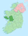
Killimor (Irish: Cill Íomair, meaning 'Íomar's church')[1] is a village in east County Galway, Ireland. It is situated on the N65 national secondary road and contains a number of facilities including a Heritage Centre, Roman Catholic Church, a Post Office, a national school, Public library, Health Centre, supermarket, pharmacy, restaurants, take-away and a number of public houses.


