
Kings Park station (LIRR)
Kings Park | |||||||||||
|---|---|---|---|---|---|---|---|---|---|---|---|
 Kings Park Station on June 15, 2009. | |||||||||||
| General information | |||||||||||
| Location | Indian Head Road & Main Street Kings Park, New York | ||||||||||
| Coordinates | 40°53′1.39″N 73°15′20.95″W / 40.8837194°N 73.2558194°W | ||||||||||
| Owned by | Long Island Rail Road | ||||||||||
| Line(s) | |||||||||||
| Platforms | 2 side platforms | ||||||||||
| Tracks | 2 | ||||||||||
| Connections | |||||||||||
| Construction | |||||||||||
| Parking | Yes; Free | ||||||||||
| Bicycle facilities | Yes | ||||||||||
| Accessible | Yes | ||||||||||
| Other information | |||||||||||
| Fare zone | 10 | ||||||||||
| History | |||||||||||
| Opened | 1872 | ||||||||||
| Rebuilt | 1948 | ||||||||||
| Previous names | St. Johnsland (1872–1891) | ||||||||||
| Passengers | |||||||||||
| 2006 | 1,876[1] | ||||||||||
| Services | |||||||||||
| |||||||||||
Kings Park is a station on the Port Jefferson Branch of the Long Island Rail Road. It is located at the southwest corner of Suffolk CR 14 (Indian Head Road) and NY 25A (Main Street) in Kings Park, New York. This train station is located in the Kings Park Central School District.
History
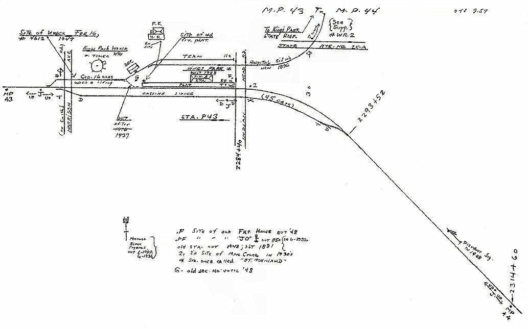
Originally known as St. Johnsland station when it was built by Charles Hallett of Riverhead for the Smithtown and Port Jefferson Railroad between November and December 1872, it was renamed Kings Park station in June 1891. The Kings Park area was the site of a major derailment on February 16, 1947, but there were no casualties.[2] The station was rebuilt in 1948 with an attached freight storage area, and rebuilt again during the 1990s. Kings Park station also had a spur called the Kings Park Psychiatric Center Spur to the former Kings Park Psychiatric Center, which was originally built in 1896,[3] and officially decommissioned in 1971, although trains were used to bring coal to the hospital until 1987. Today the right-of-way serves as the Kings Park Hike and Bike Trail,[4][5] which leads to the Nissequogue River State Park.
Station layout
This station has two high-level side platforms, each 12 cars long. Both tracks serve trains in either direction, and merge into a single track on both sides of the station.
| Ground/platform level Exit/entrance, parking, and pedestrian bridge | |
| Platform A, doors will open on the right | |
| Track 1 | ← Port Jefferson Branch toward Huntington, Jamaica, Atlantic or Penn (Northport) Port Jefferson Branch toward Port Jefferson (Smithtown) → |
| Track 2 | ← Port Jefferson Branch toward Huntington, Jamaica, Atlantic or Penn (Northport) Port Jefferson Branch toward Port Jefferson (Smithtown) → |
| Platform B, doors will open on the right | |
References
- ^ Average weekday, 2006 LIRR Origin and Destination Study
- ^ Long Island Rail Road Wrecks
- ^ Mileposts 43-44 Kings Park (Bob Emery Map; September 1957; TrainsAreFun.com)
- ^ Kings Park State Hospital Spur (Train Web)
- ^ Kings Park Hike & Bike Trail (TrailLink.com)
External links
![]() Media related to Kings Park (LIRR station) at Wikimedia Commons
Media related to Kings Park (LIRR station) at Wikimedia Commons
- Kings Park – LIRR
- Kings Park LIRR timetable
- Kings Park State Hospital Spur (Unofficial LIRR History)
- Kings Park State Hospital Spur (Arrt's Arrchives)
- Kings Park Station History (Steve Lynch's LIRR Maps, Photos, Charts, etc.) (TrainsAreFun.com)
- Station from Indian Head Road from Google Maps Street View
- FOX Interlocking (The LIRR Today)