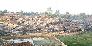
Kutupalong refugee camp
Kutupalong refugee camp
কুতুপালং শরনার্থী শিবির | |
|---|---|
 Kutupalong refugee camp in Bangladesh (Photo taken by Maaz Hussain/VOA) | |
| Coordinates: 21°12′45″N 92°09′48″E / 21.2126°N 92.1634°E | |
| Country | |
| Division | Chittagong Division |
| District | Cox's Bazar District |
| Upazila | Ukhia Upazila |
| Population (17 October 2017)[1] | |
| • Total | 22,241 (main camp) 547,616 (expansion site) |
Kutupalong refugee camp (Bengali: কুতুপালং শরনার্থী শিবির) is a refugee camp in Ukhia, Cox's Bazar, Bangladesh, inhabited mostly by Rohingya Muslims that have fled from persecution in neighboring Myanmar.[2][3] It is one of two government-run refugee camps in Cox's Bazar, the other being the Nayapara refugee camp.[4] The two refugee camps had a combined population of around 34,000 registered refugees in July 2017.[5] In September 2017, the United Nations High Commissioner for Refugees (UNHCR) estimated that the combined population of the two refugee camps had increased to over 77,000.[6]
"Kutupalong refugee camp" may also refer to the makeshift camps that have sprung up adjacent to the government-operated camp, although these are not officially part of the refugee camp. Makeshift camps at Kutupalong and surrounding areas have grown to accommodate refugees fleeing Myanmar over the years. An estimated 700,000 Rohingya Muslims and Hindus have fled Myanmar into Bangladesh since 25 August 2017, when the Myanmar military began new military operations against them.
In 2017, the Kutupalong makeshift camp and surrounding camps at Ghumdum, Balukhali, Thangkhali and others swelled rapidly and merged into each other due to an unprecedented influx of refugees. The International Organization for Migration refers to the collective settlement as the Kutupalong–Balukhali expansion site.[7] As of 14 January 2018, the expansion site had a combined population of 547,616, making it the world's largest refugee camp, ahead of Dadaab in Kenya which had 245,126 residents as of April 2017.[1][8]
References
- ^ a b "How Suu Kyi sees the Rohingya crisis". BBC News. 25 January 2018. Retrieved 26 January 2018.
- ^ "The young and the hopeless in Bangladesh's camps". UNHCR. United Nations High Commissioner for Refugees. Retrieved 14 July 2017.
- ^ "Rohingya huddled in Bangladesh camps fear plan to move them on". Reuters. 2015. Retrieved 14 July 2017.
- ^ "Stories from the Rohingya Camps in Bangladesh". 5 September 2016. Retrieved 14 July 2017.
- ^ "Shelter urgently needed for Rohingya fleeing Myanmar violence". UNHCR. United Nations High Commissioner for Refugees. Retrieved 21 December 2017.
- ^ Judah, Jacob (15 September 2017). "Rohingya influx strains camp resources in Bangladesh". UNHCR. United Nations High Commissioner for Refugees. Retrieved 4 October 2017.
- ^ "Cox's Bazar: Kutupalong-Balukhali expansion sites Footpath and Access road as of 05 Dec 2017" (PDF). International Organization for Migration. Retrieved 21 December 2017.
- ^ "Rohingya Refugee Crisis Response". IOM. International Organization for Migration. Retrieved 21 December 2017.

