Kwilu River
| Kwilu River | |
|---|---|
 | |
 | |
| Physical characteristics | |
| Mouth | 3°23′07″S 17°23′04″E / 3.385251°S 17.384491°E |
| Length | 965 kilometres (600 mi) |
| Basin features | |
| River system | Kasaï River |
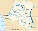
The Kwilu River is a major river that originates in Angola and flows north through Bandundu Province in the Democratic Republic of the Congo (DRC) to the city of Bandundu, where it joins the Kwango River just before this stream enters the Kasai River. In the DRC the river flows past the towns of Gungu, Kikwit, Bulungu, Bagata and Bandundu.[1] Lusanga, formerly Leverville, lies at the location where the Kwenge River joins the Kwilu, between Kikwit and Bulungu.[2]
The river is about 965 kilometres (600 mi) long. In the wet season the flooded area covers 1,550 square kilometres (600 sq mi). The headwaters of the river rise at elevations between 1,000 metres (3,300 ft) and 1,800 metres (5,900 ft) in the Angolan highlands. They drop steeply to the flat central Congo Basin at between 500 metres (1,600 ft) and 300 metres (980 ft) above sea level. A 2011 survey found 113 species of fish in 21 families and eight orders.[3]
References
- ^ Blaes 2008.
- ^ C.J. Warrington (May 1972). "M'Bwa na Basenji" (PDF). The Basenji. Retrieved 2012-02-02.
- ^ Munene & Stiassny 2011.
Sources
- Blaes, X. (October 2008). "Découpage administratif de la République Démocratique du Congo". UNOCHA and PNUD. Retrieved 2011-11-22.
{{cite web}}: Invalid|ref=harv(help) - Munene, José Justin Mbimbi Mayi; Stiassny, Melanie L. J. (2011). "Fishes of the Kwilu River (Kasai basin, central Africa): A list of species collected in the vicinity of Kikwit, Bandundu Province, Democratic Republic of Congo". Check List. 7 (5). Retrieved 2012-02-02.
{{cite journal}}: Invalid|ref=harv(help)


