Lingig
Appearance
Lingig | |
|---|---|
 Tagpupuran Blue Waters Resort | |
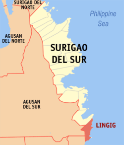
 Map of Surigao del Sur with Lingig highlighted | |
| Coordinates: 08°02′N 126°25′E / 8.033°N 126.417°E | |
| Country | Philippines |
| Region | Caraga |
| Province | Surigao del Sur |
| District | 2nd district of Surigao del Sur |
| Barangays | 18 |
| Government | |
| • Mayor | Roberto M. Luna, Jr. |
| Area | |
| • Total | 305.17 km2 (117.83 sq mi) |
| Population (2020 census)[3] | |
| • Total | 35,142 |
| • Density | 120/km2 (300/sq mi) |
| Time zone | UTC+8 (PST) |
| ZIP code | 8312 |
| IDD : area code | +63 (0)86 |
| Income class | 2nd municipal income class |
| PSGC | 166812000 |
| Electorate | 23,980 voters as of 2022 |
| Website | www |
Lingig is a second class municipality in the province of Surigao del Sur, Philippines. According to the 2020 census, it has a population of 35,142 people.[3]
The municipality is around one and a half hours away from Barangay Mangagoy, Bislig City, by bus. It is a border town of Surigao del Sur with Davao Oriental.
Barangays
Lingig is politically subdivided into 18 barangays.
- Anibongan
- Barcelona
- Bogak
- Bongan
- Handamayan
- Mahayahay
- Mandus
- Mansa-ilao
- Pagtila-an
- Palo Alto
- Poblacion
- Rajah Cabungso-an
- Sabang
- Salvacion
- San Roque
- Tagpoporan (Tagpupuran)
- Union
- Valencia
Demographics
| Year | Pop. | ±% p.a. |
|---|---|---|
| 1903 | 730 | — |
| 1939 | 5,397 | +5.71% |
| 1948 | 4,462 | −2.09% |
| 1960 | 11,225 | +7.99% |
| 1970 | 13,836 | +2.11% |
| 1975 | 19,172 | +6.76% |
| 1980 | 19,993 | +0.84% |
| 1990 | 21,015 | +0.50% |
| 1995 | 23,477 | +2.10% |
| 2000 | 26,487 | +2.62% |
| 2007 | 28,269 | +0.90% |
| 2010 | 31,544 | +4.07% |
| 2015 | 31,485 | −0.04% |
| Source: Philippine Statistics Authority[4][5][6][7] | ||
References
- ^ "Official City/Municipal 2013 Election Results". Intramuros, Manila, Philippines: Commission on Elections (COMELEC). 1 July 2013. Retrieved 5 September 2013.
- ^ "Province: SURIGAO DEL SUR". PSGC Interactive. Makati City, Philippines: National Statistical Coordination Board. Retrieved 1 April 2014.
- ^ a b Census of Population (2020). "Caraga". Total Population by Province, City, Municipality and Barangay. Philippine Statistics Authority. Retrieved 8 July 2021.
- ^ Census of Population (2015). "Caraga". Total Population by Province, City, Municipality and Barangay. Philippine Statistics Authority. Retrieved 20 June 2016.
- ^ Census of Population and Housing (2010). "Caraga" (PDF). Total Population by Province, City, Municipality and Barangay. National Statistics Office. Retrieved 29 June 2016.
- ^ Censuses of Population (1903–2007). "Caraga". Table 1. Population Enumerated in Various Censuses by Province/Highly Urbanized City: 1903 to 2007. National Statistics Office.
- ^ "Province of Surigao del Sur". Municipality Population Data. Local Water Utilities Administration Research Division. Retrieved 17 December 2016.
External links
- Philippine Standard Geographic Code
- Philippine Census Information
- Local Governance Performance Management System

