Mahra Sultanate
| Mahra Sultanate of Qishn and Socotra سلطنة المهرة في قشن وسقطرة | |||||||||
|---|---|---|---|---|---|---|---|---|---|
| State of the Protectorate of South Arabia | |||||||||
| 1549–1967 | |||||||||
|
Flag | |||||||||
 Map of the Protectorate of South Arabia in 1965. | |||||||||
| Capital | Qishn (Mahra); Tamrida/Hadibu (Socotra) | ||||||||
| • Type | Monarchy | ||||||||
| History | |||||||||
• Established | 1549 | ||||||||
• Disestablished | 1967 | ||||||||
| |||||||||

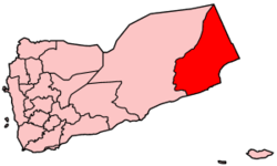
The Mahra Sultanate of Qishn and Socotra (Arabic: سلطنة المهرة في قشن وسقطرة Salṭanat al-Mahrah fī Qishn wa-Suquṭrah) or sometimes the Mahra Sultanate of Ghayda and Socotra (Arabic: سلطنة المهرة في الغيضاء وسقطرة Salṭanat al-Mahrah fī al-Ghayḍā’ wa-Suquṭrah) was a sultanate that included both the historical region of Mahra and the Indian Ocean island of Socotra in what is now eastern Yemen. It was ruled by the Banu Afrar (Arabic: بنو عفرار Banū ‘Afrār, also known as بن عفرير) dynasty and is sometimes called Mahra State in English.
During 1886, the sultanate became a British protectorate and later became a part of the Aden Protectorate. The Sultanate was abolished in 1967 upon the founding of the People's Republic of South Yemen and is now part of the Republic of Yemen.[1]
In addition to Arabic, Mehri, a Modern South Arabian language is spoken in Mahra. Mahra shares with the neighbouring Dhofar in Oman cultural traits such as the modern South Arabian language spoken and the importance of frankincense. These regions also share geographic and climatic ties, which distinguish them from the surrounding desert terrain, mostly due to the beneficial action of the khareef monsoon.
History
Between 1506 and 1512 Socotra Island was occupied by the Portuguese Empire. The Portuguese governors were Afonso de Noronha (1506 - 1509)[2] and Pêro Ferreira Fogaça (1509 - 1512). The Mahri Sultanate of Qishn and Suqutra (Quisn and Socotra) was established in 1549. In 1866 Qishn became a British protectorate. On 30 Oct 1886 Socotra and dependencies came under British protection as well.
The capitals of the Mahra Sultanate were Qishn in Mahra and Tamrida (Hadibu) on Socotra. In the 1960s, Mahra declined to join the Federation of South Arabia but remained under British protection as part of the Protectorate of South Arabia. On 16 Oct 1967 the Sultanate was abolished and Mahra became part of newly independent South Yemen which united with North Yemen in 1990 to become the Republic of Yemen. The last sultan of Mahra was Issa Bin Ali Bin Salim Banu Afrar. Today the Mahra area (without Socotra) is the Al Mahrah Governorate of Yemen.
Rulers
The Sultans of Mahra had the title of Sultan al-Dawla al-Mahriyya (Sultan Qishn wa Suqutra).[3]
Sultans
- c.1750 - 1780 `Afrar al-Mahri
- c.1780 - 1800 Taw`ari ibn `Afrar al-Mahri
- c.1800 - 1820 Sa`d ibn Taw`ari Ibn `Afrar al-Mahri
- c.1834 Sultan ibn `Amr (on Suqutra)
- c.1834 Ahmad ibn Sultan (at Qishn)
- 1835 - 1845 `Amr ibn Sa`d ibn Taw`ari Afrar al-Mahri
- 1845 - 18.. Taw`ari ibn `Ali Afrar al-Mahri
- 18.. - 18.. Ahmad ibn Sa`d Afrar al-Mahri
- 18.. - 18.. `Abd Allah ibn Sa`d Afrar al-Mahri
- 18.. - 18.. `Abd Allah ibn Salim Afrar al-Mahri
- 1875? - 1907 `Ali ibn `Abd Allah Afrar al-Mahri
- 1907 - 1928? `Abd Allah ibn `Isa Afrar al-Mahri
- 1946? - Feb 1952 Ahmad ibn `Abd Allah Afrar al-Mahri
- Feb 1952 - 1967 `Isa ibn `Ali ibn Salim Afrar al-Mahri
See also
References
- ^ Paul Dresch. A History of Modern Yemen. Cambridge, UK: Cambridge University Press, 2000
- ^ Monteiro, Alexandre. Uma página dos Descobrimentos: a ilha de Socotorá no século XVI. in National Geographic Portugal, June 2012, p. 42-45.
- ^ States of the Aden Protectorates

