Main Street–Black River Bridge
Main Street–Black River Bridge | |
 Bridge in 2013 | |
| Location | Main St. over Black R., Bessemer Township, Michigan |
|---|---|
| Coordinates | 46°28′25″N 90°0′5″W / 46.47361°N 90.00139°W |
| Area | less than one acre |
| Built | 1923 |
| Built by | Paul N. Massie |
| Architect | Michigan State Highway Dept. |
| Architectural style | Through girder bridge |
| MPS | Highway Bridges of Michigan MPS |
| NRHP reference No. | 99001514[1] |
| Added to NRHP | December 9, 1999 |
The Main Street–Black River Bridge is a bridge located on Main Street over the Black River in Ramsay, Bessemer Township, Michigan, USA. It was listed on the National Register of Historic Places in 1999.[1]
History
[edit]

In 1884, the village of Ramsay (now an unincorporated community) began developing around Hubbard and Weed's sawmill on the Black River.[2] The mill burned in 1889, but by that time Ramsay was home to the company headquarters of and workers from the nearby Castile Mining Company. At the turn of the century, Ramsay's Main Street was carried over the Black River by an older truss bridge; by the end of the 1910s, the bridge was deteriorating and was a bottleneck for vehicular traffic. The Gogebic County Road Commission asked the state to help fund a replacement bridge, and in 1922 engineers from the Michigan State Highway Department designed a bridge to span the Black river, designating it Bridge File No. 270103. A contract for $19,455.14 was awarded to Paul N. Massie of nearby Bessemer, who completed construction in 1923. Since that time, the Main Street–Black River Bridge has been essentially unaltered, and continues to carry vehicular traffic.[2]
Description
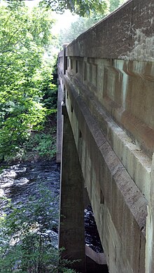
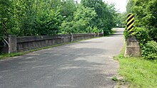
[edit]The Main Street–Black River Bridge is a concrete through girder bridge, with a main span length of 50 feet (15 m) and a complete structure length of 130 feet (40 m).[2] The structure is 27 feet 2 inches (8.28 m) wide, of which 22 feet (6.7 m) is the roadway. Three concrete girders carry the roadway: a central 50-foot (15 m) girder, and two 40-foot (12 m) girders on each end. The girders sit on tapered concrete piers. Panels are recessed in the girder walls, which are capped with heavy concrete corbels. Bronze plates stating "State Reward Bridge" are mounted on each sidewall.[2]
Significance
[edit]By 1923, the concrete through girder bridge design used for the Main Street–Black River Bridge was a well-tested standard design.[2] The Michigan State Highway Department had first delineated this type of structure in 1913-14, and used them for "spans from thirty to fifty feet in both the eighteen and twenty-foot clear roadway from curb to curb," as stated in their Seventh Biennial Report. The Highway Department used this design until about 1930, and in that span designed and built perhaps hundreds of them through the state. Most of this type of bridge were single-span structures; the triple-span design and tapered piers of the Main Street–Black River Bridge mark it as a noteworthy example of the design's potential. The bridge is visually striking when views from the river, and is historically important for enabling local vehicular transportation. Other than minor concrete spalling, the bridge is essentially unaltered and remains in good condition.[2]
See also
[edit] Transport portal
 Engineering portal
 Michigan portal
- National Register of Historic Places listings in Gogebic County, Michigan
References
[edit]- ^ a b "National Register Information System". National Register of Historic Places. National Park Service. July 9, 2010.
- ^ a b c d e f "Main Street/Black River Bridge". Michigan State Housing Development Authority: Historic Sites Online. Archived from the original on December 24, 2012. Retrieved December 22, 2011.
External links
[edit]- "Ramsay Bridge". HistoricBridges.org.
- Road bridges on the National Register of Historic Places in Michigan
- Bridges completed in 1923
- Buildings and structures in Gogebic County, Michigan
- National Register of Historic Places in Gogebic County, Michigan
- Plate girder bridges in the United States
- Concrete bridges in the United States
- 1923 establishments in Michigan


