
Martadi
Martadi
मार्तडी | |
|---|---|
 Martadi at Glance | |
 Martadi Location in Nepal | |
| Coordinates: 29°26′49″N 81°29′12″E / 29.44694°N 81.48667°E | |
| Country | |
| Zone | Seti Zone |
| District | Bajura District |
| Elevation | 2,030 m (6,660 ft) |
| Population (2011) | |
| • Total | 8,807 |
| • Religions | Hindu |
| Time zone | UTC+5:45 (Nepal Time) |
| Area code | 097 |
| Website | http://www.badimalikamun.gov.np |
Martadi is a town and seat of Bajura District in the Seti Zone of north-western Nepal. At the time of the 1991 Nepal census it had a population of 4,618 and had 942 houses in the town but now it has increased by growth rate of 2.62.[1]
The town and surrounding area is under the jurisdiction of the Martadi District Police.
Population
At the time of the 2011 Nepal census it had a population of 8,807(4,101 Female & 4,706 Male) people living in 1,290 individual Households.[2]
Colleges and School in Martadi
- Bajura Multiple Campus
It has been conditioning the bachelor level programs with affiliation to Tribhuwan University, Kirtipur, Kathmandu, Nepal.
- Badimalika English Boarding School
- Converse Academy
- Shree Malika Higher Secondary School
Photos of Martadi(Badimalika Municipality)
-
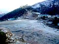 View of Army Camp
 -
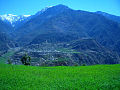 view of Martadi from Khapalta
 -
 view of mountain from Martadi Bajar


References
- ^ "Nepal Census 2001". Nepal's Village Development Committees. Digital Himalaya. Archived from the original on 2008-10-12. Retrieved 2008-08-27.
{{cite web}}: Unknown parameter|deadurl=ignored (|url-status=suggested) (help) - ^ "Nepal Census 2011" (PDF). Retrieved November 2012.
{{cite web}}: Check date values in:|accessdate=(help)
Headquarters: Martadi (today part of Badimalika) | ||
| Municipality |  | |
| Rural municipalities | ||
| Former VDCs | ||
List of municipalities and rural municipalities of Nepal | ||