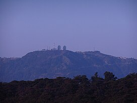
Mount Cabuyao
| Mount Cabuyao | |
|---|---|
| Mount Kabuyao | |
 Mount Kabuyao with the landmark two satellite dishes on its summit | |
| Highest point | |
| Elevation | 2,025 m (6,644 ft)[1] |
| Coordinates | 16°21′23″N 120°33′32.8″E / 16.35639°N 120.559111°E |
| Geography | |
| Location | Luzon |
| Country | Philippines |
| Region | Cordillera Administrative Region |
| Province | Benguet |
| Municipality | Tuba |
| Parent range | Cordillera Central |
| Climbing | |
| Easiest route | Hike |
Mount Cabuyao (alternatively spelled as Mount Kabuyao) is a mountain in the Philippines located in the municipality of Tuba in the province of Benguet. Its summit, rising to more than 2,000 meters above sea level,[1][2] overlooks the city of Baguio. It is commonly mistaken as Mount Santo Tomas, a taller mountain just beside it.[1]
Due to its high elevation, several communications companies constructed relay stations and radars at the summit.[3] A private observatory and AA radar station, once operated by the US Armed Forces stationed in the country, is also located here. A water catchment area was constructed to supply water to the City of Baguio and nearby towns. A small community of farmers live at the top of the mountain.[4] A town hall and a school was built for them by the local government.
Tourism

The two large satellite dishes at its summit have become a landmark in Baguio City.[1][5] The summit is also a good vantage point. During fair weather, one can see the whole City of Baguio to the east and could partially see the province of Pangasinan to the west. On a clear day, one can observe moving cargo ships passing by the South China Sea.
Hikers climb the mountain occasionally for recreational purposes.[1] Biking is also popular.[2]
Forest cover
The mountain forest is part of the protected Mount Santo Tomas watershed, which supplies water to areas near the Ben Palispis Highway and other parts of Tuba.[6] In September 2014, the Supreme Court of the Philippines ordered the temporary ceasing of development projects in a disputed area covering the forest reserve.[7][8] [9] The affected area, which has been heavily deforested, was to be developed into an eco-tourism park, as planned by Baguio City Representative Nicasio Aliping Jr.[6][7][8][9][10]
References
- ^ a b c d e "Mt. Cabuyao (2,025 +) / Mt. Sto. Tomas (2,256 +)". Pinoy Mountaineer. 19 April 2008. Retrieved 30 September 2014.
- ^ a b Tupaz, Voltaire (6 May 2012). "Bikers race to raise funds for Cordillera forests". Rappler. Retrieved 30 September 2014.
- ^ "List of Field Stations, Northern Luzon PRSD". PAGASA. Retrieved 30 September 2014.
- ^ "La Trinidad mayor wants more farmers to engage in strawberry production". DWDD (1134 kHz Metro Manila). 5 March 2014. Retrieved 1 October 2014.
- ^ "Mt. Cabuyao Troposcatter Dishes". Vista Pinas. 11 July 2010. Retrieved 1 October 2014.
- ^ a b Lacsamana, Hanna (1 June 2014). "Mt Kabuyao diggings seen to defile springs". Baguio Midland Courier. Retrieved 1 October 2014.
- ^ a b Aning, Jerome (30 September 2014). "SC stops activities in Mt. Santo Tomas forest". Philippine Daily Inquirer. Retrieved 1 October 2014.
- ^ a b Merueñas, Mark (30 September 2014). "SC stops road project in Benguet for now". GMA News. Retrieved 1 October 2014.
- ^ a b "Seeing The Damage Done In Cabuyao/Sto. Tomas Is Shocking: And That's Putting It Mildly". Cordillera Sun. 16 July 2014. Retrieved 1 October 2014.
- ^ Fontanilla, Giovani Joy (31 August 2014). "Chronicling Kabuyao's destruction". Sun.Star Baguio. Retrieved 1 October 2014.

