
Mount Pinatubo: Difference between revisions
Orphan Wiki (talk | contribs) m Reverted edits by 193.122.83.106 (talk) to last revision by ClueBot NG (HG) |
No edit summary |
||
| Line 1: | Line 1: | ||
{{pp-move-indef}} |
{{pp-move-indef}} james welton 9m cottenham village college did this ;) |
||
{{Infobox mountain |
{{Infobox mountain |
||
| name=Mount Pinatubo |
| name=Mount Pinatubo |
||
Revision as of 12:36, 21 March 2011
james welton 9m cottenham village college did this ;)
| Mount Pinatubo | |
|---|---|
 The eruption column of Mount Pinatubo on June 12, 1991, three days before the climactic eruption. | |
| Highest point | |
| Elevation | 1,485 m (4,872 ft)(current) 1,745 m (5,725 ft) (before 1991 eruption) |
| Coordinates | 15°08′30″N 120°21′00″E / 15.14167°N 120.35000°E |
| Naming | |
| Language of name | Filipino |
| Pronunciation | English: /ˌpiːnəˈtuːboʊ/ |
| Geography | |
| Location | Zambales, Luzon, Philippines Tarlac, Luzon, Philippines Pampanga, Luzon, Philippines |
| Parent range | Zambales Mountains |
| Geology | |
| Age of rock | Between 635,000 ± 80,000 and 1.1 ±; 0.09 million years[1] |
| Mountain type | Stratovolcano |
| Last eruption | 1991[2] (deaths reached to 847)[3] |
Mount Pinatubo is an active stratovolcano located on the island of Luzon, at the intersection of the borders of the Philippine provinces of Zambales, Tarlac, and Pampanga. It is located in the Tri-Cabusilan Mountain range separating the west coast of Luzon from the central plains, and is 42 km (26 mi) west of the dormant and more prominent Mount Arayat,[4] occasionally mistaken for Pinatubo. Ancestral Pinatubo was a stratovolcano made of andesite and dacite. Before 1991, the mountain was inconspicuous and heavily eroded. It was covered in dense forest which supported a population of several thousand indigenous people, the Aeta, who had fled to the mountains from the lowlands during the protracted Spanish conquest of the Philippines which began in 1565.
The volcano's Plinian/ Ultra-Plinian eruption (~VEI 6) in June 1991 produced the second largest terrestrial eruption of the 20th century (after the 1912 eruption of Novarupta) and the largest eruption in living memory.[5] The colossal 1991 eruption had a Volcanic Explosivity Index (VEI) of 5 or 6, and came some 450–500 years after the volcano's last known eruptive activity (estimated as VEI 5, the level of the 1980 eruption of Mount St. Helens), and some 1000 years after previous VEI 6 eruptive activity.[2] A VEI of 6 corresponds to 10 to 100 cubic km of released material (Pinatubo released an estimated 6 to 16 cubic km of ash). Successful predictions of the onset of the climactic eruption led to the evacuation of tens of thousands of people from the surrounding areas, saving many lives, but surrounding areas were severely damaged by pyroclastic flows, ash deposits, and later by lahars caused by rainwater remobilizing earlier volcanic deposits: thousands of houses and other buildings were destroyed.[5]
The effects of the eruption were felt worldwide. It ejected roughly 10 billion metric tonnes (10 cubic kilometres) of magma, and 20 million tons of SO2, bringing vast quantities of minerals and metals to the surface environment. It injected large amounts of aerosols into the stratosphere – more than any eruption since that of Krakatoa in 1883. Over the following months, the aerosols formed a global layer of sulfuric acid haze. Global temperatures dropped by about 0.5 °C (0.9 °F), and ozone depletion temporarily increased substantially.[6]
Overview of the area

Mount Pinatubo is part of a chain of volcanoes which lie along the western side of the edge of the island of Luzon. They are subduction volcanoes, formed by the Philippine Mobile Belt sliding over the Eurasian Plate along the Manila Trench to the west.[7] Mount Pinatubo and the other volcanoes of the West Luzon volcanic arc arise due to magma occlusion from this subduction plate boundary.
The volcano is located 87 km (55 miles) northwest of Manila, 14 km (9 miles) west of the former Clark Air Base, and 37 km (23 mi) north of the former U.S. Naval Base Subic Bay.[4] Clark Air Base's residential areas and petroleum storage facilities were in much closer proximity to the volcano than the airfield complex and neighboring Angeles City.
Several important river systems have their sources on Pinatubo, with the major rivers being the Bucao, Santo Tomas, Maloma, Tanguay, Ashley, and Kileng rivers. Before the eruption, these river systems were important ecosystems, but the eruption filled many valleys with deep pyroclastic deposits. Since 1991, the rivers have been clogged with sediment, and the valleys have seen frequent lahars. Studies show that the river systems will take many years yet to recover from the 1991 eruption.
About 500,000 people continue to live within 40 km of the mountain, with population centres including the 150,000 in Angeles City, and 30,000 at Clark Freeport Zone.
Cultural history
The word pinatubo means "Made to grow" in Tagalog and Sambal, which may suggest a knowledge of its previous eruption in about AD 1500, although there is no oral tradition among local people of earlier large eruptions. Pinatubo might instead mean culturing grounds. An indigenous group of people, the Aetas (also spelled as Ayta/Ita), had lived on the slopes of the volcano and in surrounding areas for several centuries, having fled the lowlands to escape persecution by the Spanish. They were a hunter-gatherer people who were extremely successful in surviving in the dense jungles of the area. These people also grew some staple crops such as wheat, barley, and rice.
Before the catastrophic eruption of 1991, Pinatubo was an inconspicuous volcano, unknown to most people in the surrounding areas. Its summit was 1,745 m (5,725 ft) above sea level, but only about 600 m above nearby plains, and about 200 m higher than surrounding peaks, which largely obscured it from view. Philippine President Ramon Magsaysay, a native of Zambales, named his C-47 presidential plane "Mt. Pinatubo". The plane crashed in 1957, killing the President and 24 others onboard.[8]
In total, about 30,000 people lived on the flanks of the volcano in barangays (villages) and other small settlements like Tarukan village and Maruglu. The dense jungle covering most of the mountain and surrounding peaks supported the hunter-gathering Aeta, while on the surrounding flatter areas, the abundant rainfall (almost 4 m annually) provided by the monsoon climate and the fertile volcanic soils provided excellent conditions for agriculture, and many people grew rice and other staple foods.
Aetas living near Pinatubo worship their pagan deity named Apo Namalyari "The lord of happenings/ events." who lives at the peak. According to them, this creator caused the 1991 eruption because of displeasure toward illegal loggers and Philippine National Oil Company executives who have drilled into the mountain for geothermal heat. Some of the Aetas stayed on the mountainside, hiding in caves; only three people survived.[citation needed] However after the quake, they felt as if their god had betrayed them.[9]
Geological history
Although there seems to be no local knowledge of the previous large eruptions in the Pinatubo area, several Aeta residents reported in 1991 that their elders recalled small explosions in the past. Pinatubo was a known geothermal area before the 1991 eruption, and small steam explosions are quite common in such areas. It was only after volcanic activity began in 1991 that geologists studied the eruptive history of the region in any detail. Eruptions at the site can be divided into two major eras.
Ancestral Pinatubo

Much of the rugged land surrounding the present volcano consists of remnants of 'ancestral' Pinatubo. This volcano was located roughly in the same place as the present mountain, and activity seems to have begun about 1.1 million years ago. Ancestral Pinatubo may have reached a height of up to 2,300 m (7,550 ft) above sea level, based on profile fitting to the remaining lower slopes.
Several mountains near modern Pinatubo are old satellite vents of ancestral Pinatubo, formed from volcanic plugs and lava domes. Some nearby peaks are also remnants of ancestral Pinatubo, formed from erosion-resistant parts of the old mountain slopes left behind when the less resistant parts were eroded by weathering.
The eruptive activity of ancestral Pinatubo was much less explosive than modern Pinatubo, and probably ended about 45,000 years ago. After a long period of dormancy, modern Pinatubo was born in eruptions beginning about 35,000 years ago.
Peaks like Mt. Negron, Mt. Cuadrado, Mt. Dorst and Mt Donald are believed to have been part of the volcano's original peak. Despite becoming heavily silted with mud deposits, rivers like Tarlac River and Abacan River still flow through the mountain's summit.
Modern Pinatubo
The birth of modern Pinatubo occurred in the most explosive eruption in its history, which deposited pyroclastic flow material up to 100 meters thick on all sides of the mountain. The total volume of material erupted may have been up to 25 cubic kilometers (6 mile³), and the removal of this amount of material from the underlying magma chamber led to the formation of a large caldera which was filled with water by monsoon rains several months after the climatic eruption, Lake Pinatubo has since become a good tourist attraction, the preffered route is through Barangay Santa Juliana in Capas, Tarlac.
Earlier large eruptions occurred 17,000, 9000, 6000 – 5000, and 3900 – 2300± years ago. Each of these eruptions seems to have been very large, ejecting more than 10 km³ of material and covering large parts of the surrounding areas with pyroclastic flow deposits. Scientists estimate that the most recent eruption before 1991 happened about 450 years ago, and after that, the volcano lay dormant. Its slopes became completely covered in dense rainforest and eroded into gullies and ravines.[10]
1991 awakening
On July 16, 1990, the major 1990 Luzon earthquake of magnitude 7.7 struck central Luzon. This was the largest earthquake recorded in 1990,[11][12] comparable in size to the 1906 San Francisco earthquake and the 2008 Sichuan earthquake. Its epicenter was in Rizal, Nueva Ecija municipality,[13] about 100 km northeast of Pinatubo, and faulted northwest-southeast through three provinces. It also followed the Philippine Fault System west as far as Baguio City, which was devastated, and is located about 80 km north-northeast of Pinatubo, leading volcanologists to speculate that it might ultimately have triggered the 1991 eruption, although this is impossible to prove conclusively. Two weeks after the earthquake, local residents reported steam coming from the volcano, but scientists who visited the mountain in response found only small landslides rather than any eruptive activity.
On March 15, 1991, a succession of earthquakes was felt by villagers on the northwestern side of the volcano. Further earthquakes of increasing intensity were felt over the next two weeks, and it became clear some kind of volcanic activity was likely. On April 2, the volcano awoke, with phreatic eruptions occurring near the summit along a 1.5 km long fissure. Over the next few weeks, small eruptions continued, dusting the surrounding areas with Volcanic ash. Seismographs recorded hundreds of small earthquakes every day.
Scientists immediately installed monitoring equipment and analyzed the volcano for clues as to its previous eruptive history. Radiocarbon dating of charcoal found in old volcanic deposits revealed three major explosive eruptions in recent millennia, about 5500, 3500 and 500 years ago. Geological mapping showed that much of the surrounding plains were formed by lahar deposits from previous eruptions.
Volcanic activity increased throughout May. Measurements of sulfur dioxide emissions showed a rapid increase from 500 tons per day by May 13 to 5,000 tons/day by May 28. This implied that there was a rising column of fresh magma beneath the volcano. After May 28, the amount of SO2 being emitted decreased substantially, raising fears that the degassing of the magma had been blocked somehow, leading to a pressure build-up in the magma chamber and a high likelihood of explosive eruptions.
The first magmatic eruptions occurred on June 3, and the first large explosion on June 7 generated an ash column 7 km (4.5 miles) high. The Philippine Institute of Volcanology and Seismology (PHIVOLCS) issued a warning indicating the possibility of a major eruption within two weeks.
Evacuation

Given all the signs that a very large eruption was imminent, PHIVOLCS – assisted by the U.S. Geological Survey – worked to convince local inhabitants of the severity of the threat. A false warning might have led to cynicism about any later warnings, but delaying a warning until an eruption began might lead to thousands of deaths, so the volcanologists were under some pressure to deliver a timely and accurate assessment of the volcanic risk.
Three successive evacuation zones were defined, the innermost containing everything within 10 km of the volcano's summit, the second extending from 10 to 20 km from the summit, and the third extending from 20 to 40 km from the summit (Clark Air Base and Angeles City were in this zone). The 10 km and 10–20 km zones had a total population of about 40,000, while some 331,000 people lived in the 20–40 km zone. Five stages of volcanic alert were defined, from level 1 (low level seismic disturbances) up to level 5 (major eruption in progress). Daily alerts were issued stating the alert level and associated danger area, and the information was announced in major national and local newspapers, on radio and television stations, by nongovernmental organizations (NGOs), and directly to the endangered inhabitants.
Many of the Aeta who lived on the slopes of the volcano left their villages of their own volition when the first explosions began in April, gathering in a village about 12 km from the summit. They moved to increasingly distant villages as the eruptions escalated, some Aeta moving up to nine times in the two months preceding the cataclysmic eruption
The first formal evacuations were ordered from the 10 km zone on April 7. Evacuation of the 10–20 km zone was ordered when a level 4 alert was issued on June 7. A level 5 alert triggered evacuation of the 20–40 km zone on June 13, and in all some 60,000 people had left the area within 30 km of the volcano before June 15. Most people temporarily relocated to Manila and Quezon City, with some 30,000 using the Amoranto Velodrome in Quezon City as an evacuee camp.
Eruptions' climactic buildup

In early June, tiltmeter measurements had shown that the volcano was inflating, evidently due to growing amounts of magma filling the reservoir beneath the summit. At the same time, seismic activity, previously concentrated at a depth of a few kilometers below a point about 5 km northwest of the summit, shifted to shallow depths just below the summit. On June 7, the first magmatic eruptions took place with the formation of a lava dome at the summit of the volcano. The dome grew substantially over the next five days, reaching a maximum diameter of about 200 m and a height of 40 m.
A small explosion at 03:41 on June 12 marked the beginning of a new, more violent phase of the eruption. A few hours later, large explosions lasting about half an hour generated an eruption column which quickly reached heights of over 19 km, and which generated pyroclastic flows extending up to 4 km from the summit in some river valleys. Fourteen hours later, a 15-minute eruption hurled ash to heights of 24 km. Friction in the uprushing ash column generated abundant lightning.
A third large eruption began at 08:41 on June 13, after an intense swarm of small earthquakes over the previous two hours. It lasted about five minutes, and the eruption column once again reached 24 km. After three hours of quiet, seismic activity began, growing more and more intense over the next 24 hours, until a three-minute eruption generated a 21 km-high eruption column at 13:09 on June 14.
Tephra fall from these four large eruptions was extensive to the southwest of the volcano. Two hours after the last of these four explosions, a series of eruptions began which lasted for the next 24 hours, and which saw the production of much larger pyroclastic flows and surges which travelled several kilometres down river valleys on the flanks of the volcano.
Dacite was the igneous rock making up the tephra in these eruptions and in the following climactic event. The most abundant phenocryst minerals were hornblende and plagioclase, but an unusual phenocryst mineral was also present—the calcium sulfate, anhydrite. The dacite magma was more oxidized than most magmas, and the sulfur-rich nature of the eruption was probably causally related to the redox state.
The climactic eruption
All the seismographs at Clark Air Base had been rendered inoperative by 14:30 on June 15, mostly by pyroclastic density currents. Intense atmospheric pressure variation was also recorded.

On the same day, Typhoon Yunya struck the island, passing about 75 km (50 miles) north of the volcano. The typhoon rains made direct visual observations of the eruption impossible, but measurements showed that ash was ejected to heights of 34 km (21 miles) by the most violent phase of the eruption, which lasted about three hours. Pyroclastic flows poured from the summit, reaching as far as 16 km away from it. Typhoon rains mixed with the ash deposits caused massive lahars.
The ash cloud from the volcano covered an area of some 125,000 km² (50,000 mi²), bringing total darkness to much of central Luzon. Almost all of the island received some ashfall, which formed a heavy, rain-saturated snow-like blanket. Tephra fell over most of the South China Sea and ashfall was recorded as far away as Vietnam, Cambodia and Malaysia.
Twelve days after the first magmatic eruptions of June 3, on June 15, 1991, by about 22:30, and about nine hours after the onset of the most recent climactic phase, atmospheric pressure waves had decreased to the pre-eruption levels. No seismic records were available at this time, but volcanologists believe 22:30 marked the end of the climactic eruption.
Vast quantities of minerals and metals were brought to the surface. Overall, introduced to the surface environment, was an estimated 800,000 tons of zinc, 600,000 tons of copper, 550,000 tons of chromium, 300,000 tons of nickel, 100,000 tons of lead, 10,000 tons of arsenic, 1000 tons of cadmium, and 800 tons of mercury.[14]
Aftermath

In all, the eruption ejected about ten cubic kilometres (2.5 mile³) of material, making it the largest eruption since that of Novarupta in 1912 and some ten times larger than the 1980 eruption of Mount St. Helens. Ejected material such as tephra fallout and pyroclastic flow deposits are much less dense than magma, and the volume of ejected material was equivalent to about four cubic kilometres (1 mile³) of unerupted material. This colossal eruption had a Volcanic Explosivity Index of 6.[15] The former summit of the volcano was replaced by a caldera 2.5 km wide. The highest point on the caldera rim now stood 1,485 m above sea level, some 260 m lower than the pre-eruption summit.
Over 800 people were killed by the eruption,[16] mostly by roofs collapsing under the weight of accumulated wet ash, a hazard that was greatly exacerbated by the simultaneous arrival of Typhoon Yunya. The evacuation in the days preceding the eruption certainly saved tens of thousands of lives, and has been hailed as a great success for volcanology and eruption prediction.

However, since the eruption, each rainy season has brought further lahars, which have caused the displacement of thousands of people. Hundreds have died from poor sanitation in relocation camps. Agriculture in the region also suffered badly from the effects of the eruption, with hundreds of square kilometres of formerly arable land being rendered infertile, destroying the livelihoods of thousands of farmers.
The United States maintained two large military bases in the region; U.S. Naval Base Subic Bay was 75 km (50 mi.) to the southwest, while Clark Air Base was less than 25 km (16 mi.) to the east of the volcano's summit. The United States Air Force initiated a massive airlift effort to evacuate American service members and their families during and immediately following the eruption, named Operation Fiery Vigil. Most personnel were initially relocated to Guam, Okinawa, and Hawaii, although some returned to the continental United States. Clark Air Base was ultimately abandoned by the United States military, and Subic Bay reverted to Philippines control the next year following the breakdown of lease negotiations.
Local economic and social effects
The eruption of Pinatubo severely hampered the economic development of the surrounding areas. Extensive damage to buildings and infrastructure cost billions of pesos to repair, and further costs were incurred in constructing dikes and dams to control the post-eruption lahars.
In total, 364 communities and 2.1 million people were affected by the eruption, with livelihoods and houses being damaged or destroyed. More than 8,000 houses were completely destroyed, and a further 73,000 were damaged. In addition to the severe damage sustained by these communities, roads and communications were damaged or destroyed by pyroclastic flows and lahars throughout the areas surrounding the volcanoes. The estimated cost of repairing the damage to infrastructure was 3.8 billion pesos.
Many reforestation projects were destroyed in the eruption, with a total area of 150 square kilometres (37,000 acres) valued at 125 million pesos destroyed. Agriculture was heavily disrupted, with 800 square kilometres (200,000 acres) of rice-growing farmland destroyed, and almost 800,000 head of livestock and poultry killed. The cost to agriculture of eruption effects was estimated to be 1.5 billion pesos.

Damage to healthcare facilities, and the spread of illnesses in relocation facilities, led to soaring death rates in the months following the eruption. Education for thousands of children was seriously disrupted by the destruction of schools in the eruption. The gross regional domestic product of the Pinatubo area accounted for about 10% of the total Philippine gross domestic product. The GRDP had been growing at 5% annually before the eruption, but fell by more than 3% from 1990 to 1991.
Global environmental effects
The powerful eruption of such an enormous volume of lava and ash injected significant quantities of aerosols and dust into the stratosphere. Sulfur dioxide oxidised in the atmosphere to produce a haze of sulfuric acid droplets, which gradually spread throughout the stratosphere over the year following the eruption. The injection of aerosols into the stratosphere is thought to have been the largest since the eruption of Krakatoa in 1883, with a total mass of SO2 of about 17 million tons being injected—the largest volume ever recorded by modern instruments (see chart and figure).
This very large stratospheric injection resulted in a reduction in the normal amount of sunlight reaching the Earth's surface by roughly 10% (see figure). This led to a decrease in northern hemisphere average temperatures of 0.5–0.6 °C (0.9–1.1 °F), and a global fall of about 0.4 °C (0.7 °F).[17][18] At the same time, the temperature in the stratosphere rose to several degrees higher than normal, due to absorption of radiation by the aerosols. The stratospheric cloud from the eruption persisted in the atmosphere for three years after the eruption.

The eruption had a significant effect on ozone levels in the atmosphere, causing a large increase in the destruction rate of ozone. Ozone levels at mid-latitudes reached their lowest recorded levels, while in the southern hemisphere winter of 1992, the ozone hole over Antarctica reached its largest ever size until then, with the fastest recorded ozone depletion rates. The eruption of Mount Hudson in Chile in August 1991 also contributed to southern hemisphere ozone destruction, with measurements showing a sharp decrease in ozone levels at the tropopause when the aerosol clouds from Pinatubo and Hudson arrived.
Another noticeable effect of the dust in the atmosphere was the appearance of lunar eclipses. Normally even at mid-eclipse, the moon is still visible although much dimmed, but in the year following the Pinatubo eruption, the moon was hardly visible at all during eclipses, due to much greater absorption of sunlight by dust in the atmosphere.
The area since 1991
Following the climactic eruption of June 15, 1991, activity at the volcano continued at a much lower level, with continuous ash eruptions lasting until August 1991 and episodic eruptions continuing for another month. Activity then remained low until July 1992 when a new lava dome started growing in the caldera. Volcanologists suspected that further violent eruptions could be possible, and some areas were evacuated. However, the eruption was only minor and since that episode, the volcano has been quiet.

After eruptions ended, a crater lake, Lake Pinatubo, formed in the 1991 caldera, with the 1992 lava dome forming an island. Initially, the lake was hot and highly acidic, with a minimum pH of 2 and a temperature of about 40 °C. Subsequent rainfall cooled and diluted the lake, lowering the temperature to 26 °C and raising the pH to 5.5 by 2003.
The lake increased in depth by about 1 meter per month on average, until September 2001, when fears that the walls of the crater might be unstable prompted the Philippine government to order a controlled draining of the lake. 9,000 people were once again evacuated from surrounding areas in case a large flood was accidentally triggered. Workers cut a 5 m notch in the crater rim, and successfully drained about a quarter of the lake's volume.[19]
The Aeta people were the hardest hit by the eruption. After the areas surrounding the volcano were declared safe, many Aetas returned to their old villages only to find them destroyed by pyroclastic and lahar deposits. Some were able to return to their former way of life, but most moved instead to government-organized resettlement areas. Conditions on these were poor, with each family receiving only small plots of land not ideal for growing crops. Many Aeta found casual labor working for lowland farmers, and overall Aeta society became much more fragmented, and reliant on and integrated with lowland culture.[20]
Activity since 1991
Since 1991, Pinatubo has remained active, with twenty activity events reported in 1992, three in 1993, four in 1994, two in 1995, and one each in 1996 and 2002.[21]
Pinatubo in Folklore
There are varying stories told by elders regarding the mountain, among the most known legend states that it was once a Batung Mabye which is kapampangan for living stone, it was said to have been planted on a kingdom by a displeased sorcerer but relocated by a hero. The mountain was soon turned into the abode of Apo Namalyari, the god of the Sambal, aeta and kapampangans living on the Zambales range, it was said to comprise of the whole mountain range until Sinukuan of Mount Arayat, the god of the kapampangans had a strong rivalry with Namalyari, their fight which took place over the center plains involved the shattering of the mountain into smaller bodies while Mount Arayat lost it's center peak.In other variations, Pinatubo's peak shattered because of Namalyari's immense fury in an attempt to teach humans the meaning of fear and as a form of punishment for their misdeeds.
Gallery
-
 Explosive eruption, early June 1991
 -
 Snow-like ashfall caused by heavy rain mixing with ash columns
 -
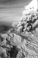
 Erosional dissection of ash deposits on Pinatubo
 -
 Aircraft hangars at Clark Air Base destroyed by ashfall
 -
 Pinatubo crater lake in Sep. 2006
 -
 Lahars from Pinatubo volcano fill the broad Santo Tomás River valley SW of the volcano


See also
- Active volcanoes in the Philippines
- Inactive volcanoes in the Philippines
- Potentially active volcanos in the Philippines
- List of volcanic eruptions by death toll
- Timetable of major worldwide volcanic eruptions
Notes
- ^ "Pinatubo Volcano". The Philippine Institute of Volcanology and Seismology (PHIVOLCS).
- ^ a b "Pinatubo: Eruptive History". Global Volcanism Program. Smithsonian Institution. Retrieved 2009-01-01.
- ^ CoolGeography - Mount Pinatubo
- ^ a b Tactical Pilotage Chart, Sheet K-11B, Defense Mapping Agency, Department of Defense, 1982.
- ^ a b "The Cataclysmic 1991 Eruption of Mount Pinatubo, Philippines". Retrieved 2007-04-09.
- ^ "Mt. Pinatubo's cloud shades global climate". Science News. Retrieved 2010-03-07.
- ^ Topinka, Lyn (July 13, 2009). "Description: Mount Pinatubo, Philippines". United States Geological Survey. Retrieved April 18, 2010.
- ^ Dominico C. Moneva (2006-03-18). "Speak out: Magsaysay's death". Sun Star Cebu. Retrieved 2008-03-21.
- ^ Loeb, Vernon (1991-07-21). "Natives Who Worship Pinatubo Feel Its Wrath". Seattle Times. Retrieved 2008-11-22.
- ^ Newhall, Christopher G. (1996). "Eruptive history of Mount Pinatubo". FIRE and MUD: Eruptions and Lahars of Mount Pinatubo, Philippines. Philippine Institute of Volcanology and Seismology; University of Washington Press. ISBN 0-295-97585-7.
{{cite book}}: Unknown parameter|coauthors=ignored (|author=suggested) (help) - ^ USGS. "Earthquake Information for 1990". Retrieved 2010-03-06.
- ^ USGS Earthquake Magnitude Policy
- ^
"The July 16 Luzon Earthquake: A Technical Monograph". Inter-Agency Committee for Documenting and Establishing Database on the July 1990 Earthquake. Philippine Institute of Volcanology and Seismology. 2001. Retrieved 2009-01-07.
{{cite web}}: Cite has empty unknown parameter:|coauthors=(help) - ^ Garret, R.G. (2000). "Natural sources of metals in the environment". Human and Ecological Risk Assessment: an International Journal. 6 (6): 945–963. doi:10.1080/10807030091124383.
{{cite journal}}: Unknown parameter|month=ignored (help) - ^ "Mt. Pinatubo, Luzon, Philippines". National Geophysical Data Center (U.S. NOAA). Retrieved 2007-12-02.
- ^ "Ashfall, Pyroclastic Flow, Lahar: The Aftermath". Pinatubu Volcano: The Sleeping Giant Awakens. expo.edu.ph.
{{cite book}}: External link in|publisher= - ^ "Mt. Pinatubo's cloud shades global climate". Science News. Retrieved 2010-03-07.
- ^ Ward, Peter L. (2 April 2009). "Sulfur Dioxide Initiates Global Climate Change in Four Ways" (PDF). Thin Solid Films. 517 (11): 3188–3203. doi:10.1016/j.tsf.2009.01.005. Retrieved 2010-03-19.
- ^ Filipinos return as volcano lake drains, BBC News, 7 September 2001.
- ^ Shimizu, Hiromu (2002), Struggling for Existence after the Pinatubo Eruption 1991: Catastrophe, Suffering and Rebirth of Ayta Communities. Paper presented inter-congress of the International Union of Anthropological and Ethnological Sciences, Tokyo, Japan. Retrieved from the original on 2004-08-15.
- ^ "Pinatubo : Monthly Reports" (Document). Global Volcanism Program.
{{cite document}}: Unknown parameter|url=ignored (help)
References
- Decker, R. and Decker, B. (1997) Volcanoes, 3rd edition, WH Freeman, New York.
- McCormick, M. Patrick; et al. (1995). "Atmospheric effects of the Mt Pinatubo eruption". Nature. 373 (6513): 399–404. doi:10.1038/373399a0.
{{cite journal}}: Explicit use of et al. in:|author=(help) - Rantucci, Giovanni (1994). Geological Disasters In The Philippines: The July 1990 Earthquake And The June 1991 Eruption of Mount Pinatubo. Description, effects and lessons learned. Philippine Institute of Volcanology and Seismology (PHIVOLCS). ISBN 9780788120756. Retrieved 2009-08-15.
{{cite book}}: Cite has empty unknown parameter:|coauthors=(help) - Self, S. (1998). "Fire and Mud, Eruptions and Lahars of Mount Pinatubo, Philippines" (Document). Washington: Smithsonian Institution - Global Volcanism Program. p. 1126.
{{cite document}}: Cite has empty unknown parameter:|issue=(help); Unknown parameter|accessdate=ignored (help); Unknown parameter|coauthors=ignored (|author=suggested) (help); Unknown parameter|contribution=ignored (help); Unknown parameter|editors=ignored (help); Unknown parameter|url=ignored (help) - Scaillet, B. and Evans, B. W. (1999) The June 15, 1991 Eruption of Mount Pinatubo. I. Phase Equilibria and Pre-eruption P–T–fO2–fH2O Conditions of the Dacite Magma. Journal of Petrology, v. 40, 381–411.
- Stimac J.A., Goff F., Counce D., Larocque A.C.L., Hilton D.R. (2003), The crater lake and hydrothermal system of Mount Pinatubo, Philippines: evolution in the decade after eruption, Bulletin of Volcanology, v. 66, p. 149–167
- Wiesner, M.G., Wetzel, A. Catane, S.G., Listanco, E.L. and Mirabueno, H.T. (2004) Grain size, areal thickness distribution and controls on sedimentation of the 1991 Mount Pinatubo tephra layer in the South China Sea. Bulletin of Volcanology, v. 66, 226–242.
- Dhot, S. Mt Pinatubo Safety.
External links
- Philippine Institute of Volcanology and Seismology Mount Pinatubo page
- Weather effects of the 1991 eruption
- CVO Pinatubo photo archive
- The Cataclysmic 1991 Eruption of Mount Pinatubo, Philippines
Template:Link GA Template:Link GA Template:Link FA Template:Link FA
- 1991 natural disasters
- 20th-century volcanic events
- Active volcanoes
- Active volcanoes of the Philippines
- 1991 in the Philippines
- Crater lakes
- Mountains of the Philippines
- Natural disasters in the Philippines
- Stratovolcanoes
- Subduction volcanoes
- VEI-6 volcanoes
- Volcanic calderas
- Volcanic events
- Volcanoes of Luzon
- Zambales