
Na Mokulua

Nā Mokulua (meaning, in Hawaiian, "the two islands") are two islets off the windward coast of Oahu in the Hawaiian Islands. They are also commonly known as "The Mokes" (rhymes with "smokes") or the "Twin Islands". The islets are often photographed, and are located about 0.75 miles off Lanikai, a neighborhood of Kailua, Hawai‘i.
The larger island (on the left when looking from Lanikai) is Moku Nui and the smaller is Moku Iki. They are part of the Hawaii State Seabird Sanctuary and activities on them as well as off-limit areas on them are regulated by law.[1] Specifically, the smaller islet, Moku Iki, is off-limits to visitors, as is the interior of Moku Nui. Also, no pets are allowed. Many birds nest in ground burrows on the islands.
The islands formed between 2.7 and 3.9 million years ago. The two islands are composed of many basaltic intrusive igneous dikes, often called a dike swarm. These dikes are a part of the larger Ko'olau shield.[2]
Locals surf the breaks on both sides of Moku Nui and spearfish alongside tiger sharks where they are known to hang out on the ocean side drop-off.[citation needed] Kayak and Outrigger Canoe tours to the islands are very popular but laws prohibit deliveries to Kailua or Lanikai Beach. In May 2011, a kayak tourist was swept off the rocks and drowned [3]
-
 View from Lanikai Beach at daylight
 -
 View of Moku Iki from the beach of Moku Nui
 -
 Ocean cove on north side of Moku Nui
 -
 Hawaii State Seabird Sanctuary in Moku Nui
 -
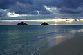 View from Lanikai Beach at dawn
 -
 The Mokes from the coast of Lanikai Beach


References
- ^ "Hawaii State DLNR Rules Regulating Wildlife Sanctuaries" (PDF). Hawaii State DLNR Rules Regulating Wildlife Sanctuaries.
- ^ "Hawai'i's Coastline". University of Hawai'i Coastal Geology Group.
- ^ "Body of missing kayaker recovered off Mokulua Islands". Hawaii News Now. Retrieved 8 May 2011.
21°23′20″N 157°41′56″W / 21.38889°N 157.69889°W
Islands, municipalities, and communities of Honolulu County, Hawaii, United States | |||||
|---|---|---|---|---|---|
| CDPs |
|  | |||
| Other communities | |||||
| Government |
| ||||
This Hawaiʻi state location article is a stub. You can help Wikipedia by expanding it. |