Nanshan Island
This article needs additional citations for verification. (June 2014) |
 | |
| Geography | |
|---|---|
| Location | South China Sea |
| Coordinates | 10°44′N 115°48′E / 10.733°N 115.800°E |
| Archipelago | Spratly Islands |
| Administration | |
Philippines | |
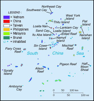
Nanshan Island (Template:Lang-tl, literally "vastness"; Chinese: 马欢岛; pinyin: Mahuan Dao; Template:Lang-vi) is the eighth largest island of Spratly Islands and the fourth largest among Philippine-occupied Spratly islands. It has an area of 7.93 hectares. It is located 98.0 miles (157.7 km) east of Pag-asa (Thitu Island). This island is administered by the Philippines as part of Kalayaan, Palawan. The island takes its name from an American military collier - the USS Nanshan (AG-3) which operated in the South China Sea from 1898-1913.
Environment
This island is a bird sanctuary. Its surroundings are highly phosphatized that superphosphate materials can be mined out on a small-scale basis. Near the fringes of the breakwaters (approx. 2 miles (3 km) from the island), intact hard coral reefs were observed to retain their natural environment and beautiful tropical fishes were seen colonizing these coral beds of varying colors. It is also covered with coconut trees, bushes and grass. It is 580 m long, on the edge of a submerged reef.
Philippine Occupation
A handful of Philippine soldiers and their families are stationed on the island, which has been inhabited since 1968 when Philippines occupied this island.[1] There are only one to two structures in this island that serve as shelters for the soldiers. The soldiers are also the guard of nearby Flat Island which lies 6 miles (10 km) north-northeast of the island which is also occupied by the Philippines.
Lawak island is claimed by the People's Republic of China, Republic of China (Taiwan), and Vietnam.
See also
- Spratly Islands
- Kalayaan, Palawan
- Policies, activities and history of the Philippines in Spratly Islands
References
- ^ Campbell, Eric (20 May 2014). "Reef Madness". ABC News. Retrieved 23 May 2014.

