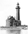
Oak Orchard Light
Appearance
 | |
 | |
| Location | On Lake Ontario, at Point Breeze in New York |
|---|---|
| Coordinates | 43°22′16″N 78°11′35″W / 43.37111°N 78.19306°W |
| Tower | |
| Constructed | 1871 |
| Height | 10.5 m (34 ft) |
| Light | |
| First lit | 1871 |
| Deactivated | 1916 |
| Focal height | 11 m (36 ft) |
| Characteristic | F W |
Oak Orchard Light was a lighthouse that operated on the shores of Lake Ontario, in New York, United States, at Point Breeze from 1871 to 1916. In 2010 a local community group built a historically accurate replica of the lighthouse near the original site on the east side of Oak Orchard Creek. Originally it had been built at the end of a long wooden pier on the west side.[2]
References
- ^ "Oak Orchard Light ARLHS USA-559". ARLHS World List of Lights. The Weidner Publishing Group. 2003. Retrieved 26 April 2011.
- ^ "The Oak Orchard Lighthouse is Built!". Oak Orchard Lighthouse. Retrieved 26 April 2011.
Further reading
- Oleszewski, Wes. Great Lakes Lighthouses, American and Canadian: A Comprehensive Directory/Guide to Great Lakes Lighthouses, (Gwinn, Michigan: Avery Color Studios, Inc., 1998) ISBN 0-932212-98-0.
- Price, Scott T. "U. S. Coast Guard Aids to Navigation: A Historical Bibliography". United States Coast Guard Historian's Office.
- U.S. Coast Guard. Historically Famous Lighthouses (Washington, D.C.: Government Printing Office, 1957).
- Wright, Larry and Wright, Patricia. Great Lakes Lighthouses Encyclopedia Hardback (Erin: Boston Mills Press, 2006) ISBN 1-55046-399-3
External links
- Oak Orchard Lighthouse Museum
- "Historic Light Station Information and Photography: New York". United States Coast Guard Historian's Office. Archived from the original on 2017-05-01.
- US-Lighthouses.com
Categories:
- Lighthouses completed in 1871
- Towers completed in 1871
- Lighthouses in New York (state)
- Buildings and structures in Orleans County, New York
- Museums in Orleans County, New York
- Transportation in Orleans County, New York
- Lighthouses of the Great Lakes
- New York (state) building and structure stubs
- United States lighthouse stubs


