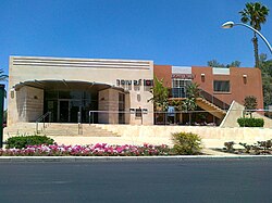
Omer, Israel
Template:Infobox Israel municipality Omer (Template:Lang-he-n) is an upscale town in the South District of Israel, bordering Beersheba. It is located on Highway 60, between Beersheba and the Shoket Junction.
History

Omer, originally known as Hevrona, was founded as a kibbutz in 1949. The early residents were demobilized Palmach soldiers. In 1951, it became a cooperative village known as Eilata. In 1953, it was re-established as a communal moshav by immigrants from Hungary and Romania and renamed Omer. The name is based on a verse from the book of Leviticus.[1]
In 1957, residents of the ma'abarot in the vicinity moved to Omer. In 1962, it was renamed Tomer and became a neighborhood of Beersheba. Since 1974, it has been an independent town and suburb of Beersheba.[1]
Pini Badash has served as mayor since 1990. In 2010, according to the Israel Central Bureau of Statistics (CBS), the population of Omer was 6,593.[2] Omer's jurisdiction is 20,126 dunams (~20.1 km²).
Economy
Omer is known for its high socio-economic ranking. It is one of three municipalities to score 10/10, along with Kokhav Yair and Savyon.[3]
Notable residents
- Guy Barnea, Olympic swimmer
- Amir Ganiel, swimmer
- Imri Ganiel, swimmer
- Roni Dalumi, singer
- Shaul Ladany, world-record-holding Olympic racewalker, Bergen-Belsen survivor, Munich Massacre survivor, and Professor of Industrial Engineering
References
- ^ a b HaReuveni, Immanuel (1999). Lexicon of the Land of Israel. Miskal - Yedioth Ahronoth Books and Chemed Books. p. 769. ISBN 965-448-413-7. Template:He icon
- ^ Cite error: The named reference
cbs localitieswas invoked but never defined (see the help page). - ^ "Local Authorities in Israel 2005, Publication #1295 - Municipality Profiles - Omer" (PDF). Israel Central Bureau of Statistics. Retrieved 2008-03-07. Template:He icon

