Oosterbeek railway station
Appearance
Oosterbeek | |||||||||||
|---|---|---|---|---|---|---|---|---|---|---|---|
 | |||||||||||
| General information | |||||||||||
| Location | Netherlands | ||||||||||
| Coordinates | 51°59′41″N 5°50′24″E / 51.99472°N 5.84000°E | ||||||||||
| Line(s) | Amsterdam–Arnhem railway | ||||||||||
| History | |||||||||||
| Opened | 1845 | ||||||||||
| Services | |||||||||||
| |||||||||||
| |||||||||||
Oosterbeek is a railway station located in Oosterbeek, Netherlands. The station opened on 16 May 1845 and is on the Amsterdam–Arnhem railway (Rhijnspoorweg). The station was originally called Oosterbeek Hoog, as there was also a station called Oosterbeek Laag, meaning Lower Oosterbeek. This railway station was located on the Arnhem–Nijmegen railway. The station is the least used on the Amsterdam–Arnhem railway, with less than 600 passengers per day.
Train services
As of 11 December 2016[update], the following train services call at this station:
- Local Sprinter service: Ede-Wageningen - Arnhem
Bus service

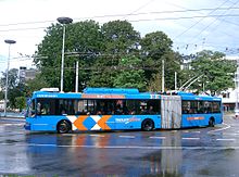
Trolleybus line 1 runs between the station, via Arnhem to Het Duifje in southern Arnhem.
External links

