Opobo–Nkoro
Opobo–Nkoro | |
|---|---|
| Country | Nigeria |
| State | Rivers State |
| Date created | 1996 |
| Seat | Opobo |
| Area | |
• Total | 50 sq mi (130 km2) |
| Time zone | UTC+1 (WAT) |
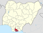
Opobo–Nkoro (also spelled Opobo/Nkoro) is a Local Government Area in Rivers State, Nigeria. It is part of the Andoni/Opobo/nkoro constituency of the Nigerian National Assembly delegation from Rivers. The capital is Opobo Town.[1]
The Opobo–Nkoro people are mainly farmers and fishermen.They are of Igbo extraction. They speak Igbo language. Just like the neighbouring Bonny, founded by Ndokis of Azuogu, slaves from the hinterland transformed the demography of the area when the Transatlantic Slave Trade was abolished. Ijaws who came in as porters also settled there and the Igbo language was adopted. Although, there are no indigenous Ijaw communities there, most Ijaw migrants and porters have fully been integrated into the original indigenous Igbo communities.
Pro-Natura International Nigeria has been assisting in community-led development in the LGA.[2]
References
- ^ "Opobo/Nkoro". AfDevInfo. Retrieved 2009-10-17.
- ^ "Opobo Nkoro Community Development Foundation Projects". Pro-Natura International Nigeria. Retrieved 2009-10-17. [dead link]
4°34′5″N 7°33′10″E / 4.56806°N 7.55278°E

