Oruro Department
Department of Oruro | |
|---|---|
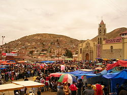
 Santuario de la Virgen del Socavón, Carnaval de Oruro, 2007 | |
 Location within Bolivia | |
| Country | |
| Capital | Oruro |
| Provinces | 16 |
| Government | |
| • Governor | Santos Tito (MAS-IPSP) |
| Area | |
• Total | 53,588 km2 (20,690 sq mi) |
| Population (2012 census) | |
• Total | 494,178 |
| • Density | 9.2/km2 (24/sq mi) |
| Time zone | UTC-4 (BOT) |
| HDI (2017) | 0.700[1] high · 5th |
| Languages | Spanish, Quechua, Aymara |
| Website | www |
Oruro (Spanish pronunciation: [oˈɾuɾo]; Quechua: Uru Uru; Aymara: Ururu) is a department in Bolivia, with an area of 53,588 km2 (20,690 sq mi). Its capital is the city of Oruro. According to the 2012 census, the Oruro department had a population of 494,178.
Provinces of Oruro
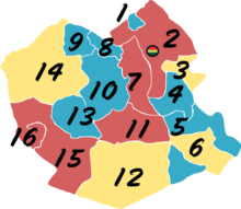
The department is divided into 16 provinces which are further subdivided into municipalities and cantons.
| Province | Map # | Area (km²) | Population (2012 census) |
Capital |  |
|---|---|---|---|---|---|
| Carangas | 10 | 5,472 | 11,041 | Corque | |
| Cercado | 2 | 5,766 | 309,277 | Oruro | |
| Eduardo Avaroa | 5 | 4,015 | 33,248 | Challapata | |
| Ladislao Cabrera | 12 | 8,818 | 14,678 | Salinas de Garci Mendoza | |
| Litoral | 13 | 2,894 | 10,409 | Huachacalla | |
| Nor Carangas | 8 | 870 | 5,502 | Huayllamarca | |
| Pantaleón Dalence | 3 | 1,210 | 29,497 | Huanuni | |
| Poopó | 4 | 3,061 | 16,775 | Poopó | |
| Puerto de Mejillones | 16 | 785 | 2,076 | La Rivera | |
| Sabaya | 15 | 5,885 | 10,924 | Sabaya | |
| Sajama | 14 | 5,790 | 9,390 | Curahuara de Carangas | |
| San Pedro de Totora | 9 | 1,487 | 5,531 | Totora | |
| Saucarí | 7 | 1,671 | 10,149 | Toledo | |
| Sebastian Pagador | 6 | 1,972 | 13,153 | Santiago de Huari | |
| Sud Carangas | 11 | 3,536 | 7,231 | Santiago de Andamarca | |
| Tomás Barrón | 1 | 356 | 5,267 | Eucaliptus |
Note: Eduardo Abaroa Province (#5) is both north of and south of Sebastián Pagador Province (#6).
Government
The chief executive office of Bolivia departments (since May 2010) is the governor; until then, the office was called the prefect, and until 2006 the prefect was appointed by the President of Bolivia. The current governor, Santos Tito of the Movement for Socialism – Political Instrument for the Sovereignty of the Peoples, was elected on 4 April 2010.
The chief legislative body of the department is the Departmental Legislative Assembly, a body also first elected on 4 April 2010. It consists of 33 members: 16 elected by each of the department's provinces; 16 elected based on proportional representation; and minority indigenous representative selected by the Uru-Chipaya people.
Template:Oruro departmental election, 2010
Languages
The languages spoken in the department are mainly Spanish, Quechua and Aymara. The following table shows the number of those belonging to the recognized group of speakers.[2]
| Language | Department | Bolivia |
|---|---|---|
| Quechua | 134,289 | 2,281,198 |
| Aymara | 127,086 | 1,525,321 |
| Guaraní | 383 | 62,575 |
| Another native | 1,943 | 49,432 |
| Spanish | 342,332 | 6,821,626 |
| Foreign | 6,878 | 250,754 |
| Only native | 30,745 | 960,491 |
| Native and Spanish | 188,963 | 2,739,407 |
| Spanish and foreign | 153,439 | 4,115,751 |
Notable people
- Evo Morales, who has been the Bolivian president since 2006, was born in the village of Isallawi near Orinoca.
Places of interest
- Sajama National Park
- Parinacota Volcano
- Sajama Lines
- Poopó Lake
- Lake Uru Uru
- Paria, first Spanish settlement in Bolivia, former Inca city.
See also
References
- ^ "Sub-national HDI - Area Database - Global Data Lab". hdi.globaldatalab.org. Retrieved 13 September 2018.
- ^ obd.descentralizacion.gov.bo Archived 18 February 2009 at the Wayback Machine (Spanish)
External links
- Oruro Travel Guide
- Weather in Oruro
- Carnaval 2009 folklore
- Technical University of Oruro
- Oruro News
- Feria Exposición
- Chisholm, Hugh, ed. (1911). . Encyclopædia Britannica (11th ed.). Cambridge University Press.
- Full information of Oruro Department


