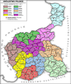
Płock Governorate
Appearance

Płock Governorate (Russian: Плоцкая губернияя Polish: Gubernia Płocka) was an administrative unit (governorate) of the Congress Poland.
It was created in 1837 from the Płock Voivodship, and had the same borders and capital (Płock) as the voivodship. In 1867 territories of the Augustów Governorate and the Płock Governorate were divided into a smaller Płock Governorate, Suwałki Governorate (consisting mostly of the Augustów Governorate territories) and recreated Łomża Governorate.
The Governorate consisted of eight counties (uyezds):
- Ciechanowski
- Lipnowski
- Mławski,
- Płocki
- Płoński
- Przasnyski
- Rypiński
- Sierpecki
Language

- By the Imperial census of 1897.[1] In bold are languages spoken by more people than the state language.
| Language | Number | percentage (%) | males | females |
|---|---|---|---|---|
| Polish | 447 685 | 80.86 | 216 794 | 230 891 |
| Yiddish | 51 215 | 9.25 | 24 538 | 26 677 |
| German | 35 931 | 6.49 | 17 409 | 18 522 |
| Russian | 15 137 | 2.73 | 13 551 | 1 586 |
| Ukrainian | 2 350 | 0.42 | 2 302 | 48 |
| Other[2] | 1 285 | 0.23 | 1 041 | 244 |
| Persons that didn't name their native language |
27 | >0.01 | 14 | 13 |
| Total | 553 633 | 100 | 275 652 | 277 981 |
References and notes
- ^ Language Statistics of 1897 Template:Ru icon
- ^ Languages, number of speakers which in all gubernia were less than 1000
External links
- Template:Pl icon Gubernia płocka w Słowniku geograficznym Królestwa Polskiego i innych krajów słowiańskich, Tom VIII (Perepiatycha — Pożajście) z 1887 r.
- Geographical Dictionary of the Kingdom of Poland

