
Palau, Sardinia
Palau
Lu Palau (Gallurese) | |
|---|---|
| Comune di Palau | |
 | |
Location of Palau  | |
 Palau Location of Palau in Sardinia  Palau Palau (Sardinia) | |
| Coordinates: 41°11′N 9°23′E / 41.183°N 9.383°E | |
| Country | Italy |
| Region | Sardinia |
| Province | Sassari (SS) |
| Frazioni | Altura, Barrabisa, Capannaccia, Capo d'Orso, Costa Serena, L'Isuledda, Le Saline, Liscia Culumba, Petralana, Porto Pollo, Porto Rafael, Pulcheddu, Punta Sardegna |
| Government | |
| • Mayor | Francesco Pala |
| Area | |
| • Total | 44.4 km2 (17.1 sq mi) |
| Elevation | 5 m (16 ft) |
| Population | |
| • Total | 4,163 |
| • Density | 94/km2 (240/sq mi) |
| Demonym | Palaesi |
| Time zone | UTC+1 (CET) |
| • Summer (DST) | UTC+2 (CEST) |
| Postal code | 07020 |
| Dialing code | 0789 |
| Website | Official website |
Palau (Gallurese: Lu Palau) is a comune (municipality) in the Province of Sassari in the Italian region Sardinia, about 220 kilometres (140 mi) north of Cagliari and about 30 kilometres (19 mi) northwest of Olbia. It was a frazione of the comune of Tempio Pausania until 1959.
It is located on Punta Sardegna, and was founded in 1875 by local shepherds.
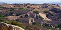
The Capo D'Orso or "Cape of the Bear" formation is nearby, at the very northwest tip of Sardinia.[3] The unique formation is a result of honeycomb weathering, a form of salt weathering.
Gallery
-
 The Capo D'Orso formation.
 -
 Monte Altura fortress, near Palau.
 -
 A tourist's map of Palau.
 -
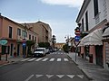 The streets of Palau.


.jpg)

References
- ^ All demographics and other statistics: Italian statistical institute Istat.
- ^ "Popolazione Residente al 1° Gennaio 2018". Italian National Institute of Statistics. Retrieved 16 March 2019.
- ^ Scheffel, Richard L.; Wernet, Susan J., eds. (1980). Natural Wonders of the World. United States of America: Reader's Digest Association, Inc. pp. 283–284. ISBN 0-89577-087-3.
External links
Wikimedia Commons has media related to Palau (Italy).

This Sardinia location article is a stub. You can help Wikipedia by expanding it. |