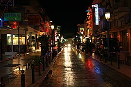
Paralia Katerinis
Paralia
Παραλία | |
|---|---|
Settlement | |
 | |
| Country | Greece |
| Administrative region | Central Macedonia |
| Regional unit | Pieria |
| Municipality | Katerini |
| Area | |
| • Municipal unit | 24.344 km2 (9.399 sq mi) |
| • Community | 1.849 km2 (0.714 sq mi) |
| Highest elevation | 20 m (70 ft) |
| Lowest elevation | 1 m (3 ft) |
| Population (2011)[1] | |
| • Municipal unit | 6,803 |
| • Municipal unit density | 280/km2 (720/sq mi) |
| • Community | 1,124 |
| • Community density | 610/km2 (1,600/sq mi) |
| Time zone | UTC+2 (EET) |
| • Summer (DST) | UTC+3 (EEST) |
| Postal code | 601 00 |
| Area code(s) | 23510 |
| Vehicle registration | KN |
Paralia (Greek: Παραλία) is a tourist seaside village and a former municipality in the eastern part of the Pieria regional unit, Greece. Since the 2011 local government reform it is part of the municipality Katerini, of which it is a municipal unit.[2] The seat of the municipality was in Kallithea. The 2011 census reported a population of 1,124 for the village of Paralia, and 6,803 for the municipal unit.[1] The municipal unit has an area of 24.344 km2, the community 1.849 km2.[3]
Geography


Paralia is situated on the west coast of the Thermaic Gulf. It lies 2 km east of Kallithea, 5 km south of Korinos and 8 km east of Katerini. Motorway 1 and the Piraeus–Platy railway (nearest station at Katerini) pass west of the village. Paralia has a small port.
Historical population
| Year | Population |
|---|---|
| 1991 | 3,100 |
| 2001 | 6,449 |
| 2011[1] | 6,803 |
See also
References
- ^ a b c "Απογραφή Πληθυσμού - Κατοικιών 2011. ΜΟΝΙΜΟΣ Πληθυσμός" (in Greek). Hellenic Statistical Authority.
- ^ Kallikratis law Greece Ministry of Interior Template:El icon
- ^ "Population & housing census 2001 (incl. area and average elevation)" (PDF) (in Greek). National Statistical Service of Greece.
