
Psari, Trikolonoi, Arcadia
This article needs additional citations for verification. (December 2023) |
Psari
Ψάρι | |
|---|---|
Settlement | |
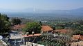
 The main road and the village church | |
 Psari | |
| Coordinates: 37°29′N 22°7′E / 37.483°N 22.117°E | |
| Country | Greece |
| Administrative region | Peloponnese |
| Regional unit | Arcadia |
| Municipality | Gortynia |
| Municipal unit | Trikolonoi |
| Community | Palamari |
| Population (2021)[1] | |
| • Total | 29 |
| Time zone | UTC+2 (EET) |
| • Summer (DST) | UTC+3 (EEST) |
| Postal code | 220 22 |
| Area code(s) | 27910 |
| Vehicle registration | TP |
Psari (Greek: Ψάρι) is a village in the Municipality of Gortynia in Arcadia. From 1997 to 2010 it was part of the Municipality of Trikolonoi. It is located at an altitude of approximately 750 meters, at a distance of 17 kilometers from Megalopoli and 11 kilometers from Stemnitsa. It is a traditional settlement with stone-built houses on the outskirts of Mount Mainalo in the heart of mountainous Arcadia. The inhabitants of the village are engaged in agriculture and livestock farming. The village celebrates every year on the feast of the Zoodochos Pege, while cultural events are held during August. The climate is mountainous with cold winters and cool summers.
History[edit]
According to archaeological findings, the village was inhabited from late antiquity at a point located northeast of the current settlement. Its original name was Paroreia. The first written reference we have about Psari is from Theodoros Kolokotronis in his memoirs, where he refers to the village under the name Psari. He says the following: "The Turks took us from close range, we were taking bread ravenously. The Turks reached us at Psari and we fought all day. My companions started to leave". It is assumed that at that time a breeder of fish-colored horses lived in the village. He used to visit the Byzantine church of Agios Georgios that exists in the village (today is the chapel of the village cemetery), since during the Turkish occupation there had been a metropolitan cathedral. During one of his visits, his presence was betrayed to the Turks by the monks of the Monastery of Agios Ioannis which existed just outside the village, causing him to flee from the residents at the last moment. Later he returned to the village and burned the monastery as revenge for the betrayal of the monks. Today the ruins of the monastery can be seen on a hill in Palamarovrysi.
Landmarks[edit]
Since 2019, the village has a museum on the history of education in modern Greece, which is housed in the old and renovated school of the village.[2] There is also the Arkadiani multipurpose hall, where there is a traditional food restaurant, a traditional sweets workshop, as well as a small museum.[3]
Gallery[edit]
-
 View from the village
 -
 Saint George Byzantine Church (13th century)
 -
 Traditional house
 -
 Cobblestone at the church of Zoodochos Pege


References[edit]
- ^ "Αποτελέσματα Απογραφής Πληθυσμού - Κατοικιών 2021, Μόνιμος Πληθυσμός κατά οικισμό" [Results of the 2021 Population - Housing Census, Permanent population by settlement] (in Greek). Hellenic Statistical Authority. 29 March 2024.
- ^ "Μουσείο Δημοτικής Εκπαίδευσης" (in Greek). Retrieved 21 August 2023.
- ^ "Αρκαδιανή" (in Greek). Retrieved 21 August 2023.