
Racu
Racu
Csíkrákos | |
|---|---|
Commune | |
 Roman Catholic fortified church | |
 Location of Racu | |
 Racu | |
| Coordinates: 46°27′0″N 25°45′45″E / 46.45000°N 25.76250°E | |
| Country | |
| County | Harghita County |
| Status | Commune |
| Government | |
| • Mayor | Attila Császár (Democratic Union of Hungarians in Romania[2]) |
| Population (2011) | |
| • Total | Approx. 1,587[1] |
| Time zone | UTC+2 (EET) |
| • Summer (DST) | UTC+3 (EEST) |
| Postal Code | 537225 |
| Area code | +40 266 |
| Website | www |
Racu (Hungarian: Csíkrákos, Hungarian pronunciation: [ˈtʃiːkraːkoʃ], meaning "Place with the Crabs of Csík") is a commune in Harghita County, Romania. It lies in the Székely Land, an ethno-cultural region in eastern Transylvania.
Component villages
The commune is composed of two villages:
| In Romanian | In Hungarian |
|---|---|
| Racu | Csíkrákos |
| Gârciu | Göröcsfalva |
Gârciu village was called Satu Nou from 1964 until 2011.
History
The villages were part of the Székely Land region of the historical Transylvania province. They belonged to Csíkszék district. After the administrative reform of Transylvania in 1876, they fell within the Csík County in the Kingdom of Hungary. After the Treaty of Trianon of 1920, they became part of Romania and fell within Ciuc County during the interwar period. In 1940, the second Vienna Award granted Northern Transylvania to Hungary and the villages were held by Hungary until 1944. After Soviet occupation, the Romanian administration returned and the commune became officially part of Romania in 1947. Between 1952 and 1960, the commune fell within the Magyar Autonomous Region, between 1960 and 1968 the Mureș-Magyar Autonomous Region. In 1968, the province was abolished, and since then, the commune has been part of Harghita County.
Demographics
The commune has an absolute Hungarian (Székely) majority. According to the 2011 census it has a population of 1,587 which 99,5% or 1,579 are Hungarian. Formerly part of Siculeni commune, the two villages broke off in 2004.
Twinnings
Maps
-
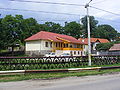
 The village hall
 -
 As Rákos on Josephinische Landaufnahme, 1769-73
 -
 House in Gârciu


References
- ^ Template:Ro harghita.insse.ro - Recensământul populaţiei şi al locuinţelor 2011, judeţul Harghita (date ptrovizorii); retrieved on January 18 2015
- ^ Template:Ro alegeri.tv - Alegeri locale 2012 - Rezultate alegeri Primăria Racu, judeţul Harghita; retrieved on January 18 2015

This Harghita County location article is a stub. You can help Wikipedia by expanding it. |