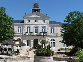
Ruffec, Charente
Appearance
Ruffec | |
|---|---|
 Town hall | |
| Coordinates: 46°01′46″N 0°12′00″E / 46.0294°N 0.2°E | |
| Country | France |
| Region | Nouvelle-Aquitaine |
| Department | Charente |
| Arrondissement | Confolens |
| Canton | Charente-Nord |
| Intercommunality | Ruffec |
| Government | |
| • Mayor (2008–2014) | Bernard Charbonneau |
| Area 1 | 13.37 km2 (5.16 sq mi) |
| Population (2008) | 3,575 |
| • Density | 270/km2 (690/sq mi) |
| Time zone | UTC+01:00 (CET) |
| • Summer (DST) | UTC+02:00 (CEST) |
| INSEE/Postal code | 16292 /16700 |
| Elevation | 83–145 m (272–476 ft) |
| 1 French Land Register data, which excludes lakes, ponds, glaciers > 1 km2 (0.386 sq mi or 247 acres) and river estuaries. | |
Ruffec is a commune in the Charente department in southwestern France.
Population
| Year | Pop. | ±% |
|---|---|---|
| 1793 | 1,937 | — |
| 1800 | 2,110 | +8.9% |
| 1806 | 2,197 | +4.1% |
| 1821 | 2,526 | +15.0% |
| 1831 | 3,004 | +18.9% |
| 1841 | 2,977 | −0.9% |
| 1846 | 3,074 | +3.3% |
| 1851 | 3,654 | +18.9% |
| 1856 | 3,109 | −14.9% |
| 1861 | 3,235 | +4.1% |
| 1866 | 3,175 | −1.9% |
| 1872 | 3,233 | +1.8% |
| 1876 | 3,385 | +4.7% |
| 1881 | 3,642 | +7.6% |
| 1886 | 3,589 | −1.5% |
| 1891 | 3,527 | −1.7% |
| 1896 | 3,426 | −2.9% |
| 1901 | 3,474 | +1.4% |
| 1906 | 3,375 | −2.8% |
| 1911 | 3,483 | +3.2% |
| 1921 | 3,231 | −7.2% |
| 1926 | 3,194 | −1.1% |
| 1931 | 3,292 | +3.1% |
| 1936 | 3,467 | +5.3% |
| 1946 | 3,874 | +11.7% |
| 1954 | 3,724 | −3.9% |
| 1962 | 4,009 | +7.7% |
| 1968 | 4,157 | +3.7% |
| 1975 | 4,241 | +2.0% |
| 1982 | 4,193 | −1.1% |
| 1990 | 3,893 | −7.2% |
| 1999 | 3,627 | −6.8% |
| 2008 | 3,575 | −1.4% |
Twin towns – sister cities
Ruffec is twinned with:
See also
References
Wikimedia Commons has media related to Ruffec (Charente).


