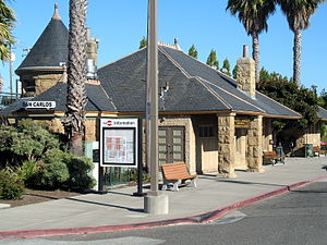
San Carlos station
Appearance
| Commuter rail | |||||||||||||||
 The Romanesque Revival style building at San Carlos Station, originally built by the Southern Pacific Railroad | |||||||||||||||
| General information | |||||||||||||||
| Location | 599 El Camino Real San Carlos, CA 94070 | ||||||||||||||
| Owned by | Peninsula Corridor Joint Powers Board | ||||||||||||||
| Line(s) | Caltrain Lua error: unknown error.Lua error in Module:Adjacent_stations at line 430: "title" is missing from the data page. | ||||||||||||||
| Platforms | 2 side platform | ||||||||||||||
| Tracks | 2 | ||||||||||||||
| Connections | SamTrans: ECR, KX, 260, 261 (Saturdays only), 295, 397, 398 Electronic Arts Shuttle, Oracle Shuttle, Redwood Shores Twin Dolphin Area Shuttle | ||||||||||||||
| Construction | |||||||||||||||
| Parking | Available | ||||||||||||||
| Bicycle facilities | Lockers available | ||||||||||||||
| Accessible | Yes | ||||||||||||||
| Other information | |||||||||||||||
| Fare zone | Fare Zone 2 | ||||||||||||||
| Passengers | |||||||||||||||
| 2017 | 1326 per weekday[1] | ||||||||||||||
| Services | |||||||||||||||
| |||||||||||||||
Southern Pacific Depot | |||||||||||||||
| Location | San Carlos, California | ||||||||||||||
| Coordinates | 37°30′29″N 122°15′28″W / 37.50806°N 122.25778°W | ||||||||||||||
| Built | 1888 | ||||||||||||||
| Architectural style | Romanesque Revival and Others | ||||||||||||||
| NRHP reference No. | 84001191 [2] | ||||||||||||||
| Added to NRHP | September 20, 1984 | ||||||||||||||
San Carlos is a Caltrain station in San Carlos, California, about midway between San Francisco and San Jose.
The Romanesque Revival style building was originally built by the Southern Pacific Railroad in 1888 and is listed on the National Register of Historic Places.
Platforms and tracks
| Northbound | ■ Local service | toward San Francisco (Belmont) |
| ■ Limited-stop service | toward San Francisco (Belmont) | |
| ■ Baby Bullet | No stops | |
| Southbound | ■ Local service | toward Gilroy (Redwood City) |
| ■ Limited-stop service | toward Tamien, Gilroy during peak hours (Redwood City) | |
| ■ Baby Bullet | No stops |
Station amenities
- Caltrain ticket machines
- Bicycle lockers
- Restaurant (Depot Cafe)
References
- ^ Caltrain. "2017 Annual Count Key Findings Report" (PDF). Retrieved 2018-01-29.
- ^ "National Register Information System". National Register of Historic Places. National Park Service. April 15, 2008.
External links
 Media related to Caltrain Station (San Carlos, California) at Wikimedia Commons
- Caltrain San Carlos station page
Categories:
- History of San Mateo County, California
- Railway stations opened in 1888
- Caltrain stations in San Mateo County, California
- National Register of Historic Places in San Mateo County, California
- Railway stations on the National Register of Historic Places in California
- Romanesque Revival architecture in California
- Southern Pacific Railroad stations in California


