Shartlesville, Pennsylvania
Shartlesville, Pennsylvania | |
|---|---|
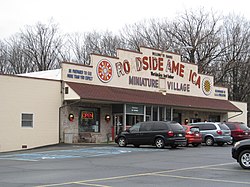
 Former Roadside America building | |
| Coordinates: 40°30′46″N 76°06′16″W / 40.51278°N 76.10444°W | |
| Country | United States |
| State | Pennsylvania |
| County | Berks |
| Township | Upper Bern |
| Elevation | 568 ft (173 m) |
| Population (2010) | |
| • Total | 455 |
| Time zone | UTC-5 (Eastern (EST)) |
| • Summer (DST) | UTC-4 (EDT) |
| ZIP Code | 19554 |
| Area code(s) | 610 & 484 |
| GNIS feature ID | 1187386[1] |
Shartlesville is a census-designated place[2] that is located in Upper Bern Township, Berks County, Pennsylvania, United States. As of the 2010 census, the population was 455 residents.[3]
History
[edit]Shartlesville, which was founded in 1765, was named for the Shartle family of farmers and innkeepers, and particularly for Peter Shartle, a pioneer settler and colonel during the Revolutionary War.[4]
Geography
[edit]This American town is located just south of Interstate 78 on the south side of Blue Mountain. It is drained by Wolf Creek south into the Northkill Creek, a tributary of the Tulpehocken Creek.
The village has a box post office with the ZIP code of 19554, but outlying areas use the Bernville ZIP code of 19506 or the Hamburg ZIP code of 19526.[5][6] It is served by the Hamburg Area School District.
Notable features
[edit]It is home to the Shartlesville Hotel, which suffered major roof damage in February 2009 during a wind storm that also knocked down a billboard in Reading, Pennsylvania, and blew off roof tiles of the Pagoda in eastern Reading.
The community was also the home of Roadside America, a large community of miniature trains and villages, located off Interstate 78, that was open to the public at that location from 1953 until 2020, when the attraction was closed, largely due to the COVID-19 pandemic.[7][8]
Just to the north of Shartlesville was the Mountain Springs Arena, which hosted events including rodeos, concerts, horse shows, demolition derbies, tractor pulls, and an annual country fair.
Demographics
[edit]| Census | Pop. | Note | %± |
|---|---|---|---|
| 2010 | 455 | — | |
| 2020 | 404 | −11.2% | |
| 2022 (est.) | 345 | [9] | −14.6% |
| US Census[10] | |||
| Racial and ethnic composition | 2010[11] | 2020[12] |
|---|---|---|
| White (non-Hispanic) | 94.29% | 90.35% |
| Hispanic or Latino (of any race) | 5.05% | 3.47% |
| Two or more races (non-Hispanic) | 0.22% | 2.97% |
| Black or African American (non-Hispanic) | 0.0% | 1.73% |
| Other (non-Hispanic) | 0.22% | 1.24% |
| Asian (non-Hispanic) | 0.22% | 0.25% |
| Native American (non-Hispanic) | 0.0% | 0.0% |
| Pacific Islander (non-Hispanic) | 0.0% | 0.0% |
See also
[edit] Media related to Shartlesville, Pennsylvania at Wikimedia Commons
References
[edit]- ^ "Shartlesville". Geographic Names Information System. United States Geological Survey, United States Department of the Interior.
- ^ Center for New Media and Promotions(C2PO). "2010 Census". census.gov. Retrieved 20 January 2015.
{{cite web}}: CS1 maint: numeric names: authors list (link) - ^ US Census Bureau. "Census.gov". Retrieved 20 January 2015.
- ^ "Berks Places: Shartlesville was founded in 1765 and its 3 hotels and miniature village drew thousands of visitors". Reading Eagle. 2021-11-08. Retrieved 2023-01-03.
- ^ "Shartlesville, PA zip code". uszip.com. Retrieved 20 January 2015.
- ^ http://www.hipcodes.com/19506/
- ^ "COVID-19 forces 'Roadside America' tourist attraction to close after 85 years". www.radio.com. 2020-11-29. Retrieved 2021-03-03.
- ^ Lynch, Michelle (2020-11-22). "Roadside America in Shartlesville to close permanently". Reading Eagle. Retrieved 2021-03-03.
- ^ "ACS Survey Population Estimate 2021".
- ^ "Census of Population and Housing". Census.gov.
- ^ "2010: DEC Redistricting Data (PL 94-171)". US Census Bureau.
- ^ "2020: DEC Redistricting Data (PL 94-171)". US Census Bureau.


