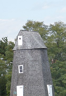
Shelter Island Windmill
Shelter Island Windmill | |
 Shelter Island Windmill, October 2008 | |
| Location | Shelter Island, New York, USA |
|---|---|
| Coordinates | 41°4′33″N 72°20′8″W / 41.07583°N 72.33556°W |
| Area | 1 acre (0.40 ha) |
| Built | 1810 |
| Architect | Dominy,Nathaniel V |
| MPS | Long Island Wind and Tide Mills TR |
| NRHP reference No. | 78001917[1] |
| Added to NRHP | December 27, 1978 |
Shelter Island Windmill is an historic windmill north of Manwaring Road in Shelter Island, Suffolk County, New York. It was built in 1810.[2] The windmill has been on Shelter Island since 1840, in its current location in 1926, and has been on the Sylvester Manor farm ever since.[3]
It was added to the National Register of Historic Places in 1978.[1]
References
- ^ a b "National Register Information System". National Register of Historic Places. National Park Service. March 13, 2009.
- ^ Raymond Smith (June 1978). "National Register of Historic Places Registration: Shelter Island Windmill". New York State Office of Parks, Recreation and Historic Preservation. Retrieved 2010-02-20. See also: "Accompanying two photos".
- ^ Sylvester Manor Educational Farm: The Windmill
External links
![]() Media related to Shelter Island Windmill at Wikimedia Commons
Media related to Shelter Island Windmill at Wikimedia Commons
- Historic American Engineering Record (HAER) No. NY-145, "Shelter Island Windmill, Manwaring Road, Shelter Island, Suffolk County, NY", 14 photos, 14 data pages, 1 photo caption page
Categories:
- Windmills completed in 1810
- Shelter Island (town), New York
- Windmills in New York
- Agricultural buildings and structures on the National Register of Historic Places in New York
- Historic American Engineering Record in New York
- Buildings and structures in Suffolk County, New York
- National Register of Historic Places in Suffolk County, New York
- Suffolk County, New York Registered Historic Place stubs


