Sidi Daoud

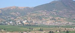
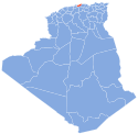
Sidi Daoud (Arabic: سيدي داوود) is a town in north-central Algeria, on the west bank of the river of oued Sebaou, a few kilometers downstream from its mouth, in eastern Boumerdès Province.
History
Before 1870, the city of Sidi Daoud was called Issers-Djedian, then Bois-Sacré (Sacred Wood). She was appointed in 1925 Abbo. In 1958, the city was part of the former department of Algiers. After independence, it takes the name of Sidi Daoud. It is the capital of a municipality dominated by the mountain of Bouberak, including the coastal village of Sahel Bouberak well known as Baterneau before independence, which is the name of the colon who was running the village.
36°51′N 3°51′E / 36.850°N 3.850°E

