Stadio San Filippo
 | |
 | |
| Location | Messina, Italy |
|---|---|
| Owner | Municipality of Messina |
| Capacity | 38,722[1] |
| Surface | Grass 105x70m |
| Construction | |
| Broke ground | 2003 |
| Opened | August 17, 2004 |
| Tenants | |
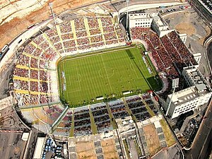
Stadio Comunale San Filippo is a football stadium in Messina, Italy.[2] It is currently the home of A.C.R. Messina.
History
The stadium was initially commissioned at the start of the 1990s, but was not finished until 2004. It was officially opened on August 17, 2004 with Messina playing host to Juventus but losing (0-1, Emerson). The first official match was a week later, on August 22, Coppa Italia match Messina-Acireale (4-0). It replaced the old 11,900 seat Stadio Comunale Giovanni Celeste, which is currently the home ground of the new club of S.S.D. Città di Messina that plays in Eccellenza Sicily group B.[3]
Structure
The total area is 114,640 sm, of which 44,300 sm reserved to car parking and 70,340 sm to a service building close to the stadium. There is no athletic track around the field, and the visibility is very good in each sector. There is a total absence of a covered seating section anywhere in the stadium, however an agreement between the team owners and the municipality aims to rectify the problem in the near future.
Trivia
The stadium name is derived from the neighborhood of Messina where it was built, but a couple of petitions hope to rename it either after the former Messina manager Franco Scoglio or the Messina native, Saint Annibale Maria di Francia.
