
Sugarcreek, Pennsylvania
Sugarcreek, Pennsylvania | |
|---|---|
| Country | United States |
| State | Pennsylvania |
| County | Venango |
| Settled | 1796 |
| Government | |
| • Type | Borough Council |
| Area | |
| • Total | 37.9 sq mi (98.1 km2) |
| Population (2000) | |
| • Total | 5,331 |
| • Density | 142.7/sq mi (55.1/km2) |
| Time zone | UTC-5 (Eastern (EST)) |
| • Summer (DST) | UTC-4 (EDT) |
| Area code | 814 |
Sugarcreek is a borough in Venango County, Pennsylvania, United States. The population was 5,331 at the 2000 census.
Geography
Sugarcreek is located at 41°25′16″N 79°49′8″W / 41.42111°N 79.81889°W (41.420993, -79.818883).[1]
According to the United States Census Bureau, the borough has a total area of 37.9 square miles (98 km2), of which, 37.4 square miles (97 km2) of it is land and 0.5 square miles (1.3 km2) of it (1.35%) is water. By area, it is the largest borough in the United States, not counting the boroughs of Alaska or those of New York City, which are entirely different kinds of "boroughs". A borough in Pennsylvania (or in Connecticut or New Jersey) is more like a town or township.
Demographics
| Census | Pop. | Note | %± |
|---|---|---|---|
| 1970 | 5,944 | — | |
| 1980 | 5,954 | 0.2% | |
| 1990 | 5,532 | −7.1% | |
| 2000 | 5,331 | −3.6% | |
| 2010 | 5,294 | −0.7% | |
| 2015 (est.) | 5,120 | [2] | −3.3% |
| Sources:[3][4][5] | |||
As of the census[4] of 2000, there were 5,331 people, 2,093 households, and 1,521 families residing in the borough. The population density was 142.7 people per square mile (55.1/km²). There were 2,245 housing units at an average density of 60.1 per square mile (23.2/km²). The racial makeup of the borough was 98.74% White, 0.32% African American, 0.13% Native American, 0.19% Asian, 0.11% from other races, and 0.51% from two or more races. Hispanic or Latino of any race were 0.28% of the population.
There were 2,093 households out of which 28.5% had children under the age of 18 living with them, 59.8% were married couples living together, 9.1% had a female householder with no husband present, and 27.3% were non-families. 24.0% of all households were made up of individuals and 11.5% had someone living alone who was 65 years of age or older. The average household size was 2.44 and the average family size was 2.88.
In the borough the population was spread out with 21.9% under the age of 18, 6.7% from 18 to 24, 26.5% from 25 to 44, 25.8% from 45 to 64, and 18.9% who were 65 years of age or older. The median age was 42 years. For every 100 females there were 90.9 males. For every 100 females age 18 and over, there were 86.9 males.
The median income for a household in the borough was $31,952, and the median income for a family was $36,926. Males had a median income of $32,875 versus $21,996 for females. The per capita income for the borough was $16,873. About 8.8% of families and 10.8% of the population were below the poverty line, including 20.1% of those under age 18 and 0.9% of those age 65 or over.
References
- ^ "US Gazetteer files: 2010, 2000, and 1990". United States Census Bureau. 2011-02-12. Retrieved 2011-04-23.
- ^ "Annual Estimates of the Resident Population for Incorporated Places: April 1, 2010 to July 1, 2015". Retrieved July 2, 2016.
- ^ "Census of Population and Housing". U.S. Census Bureau. Retrieved 11 December 2013.
- ^ a b "American FactFinder". United States Census Bureau. Retrieved 2008-01-31.
- ^ "Incorporated Places and Minor Civil Divisions Datasets: Subcounty Resident Population Estimates: April 1, 2010 to July 1, 2012". Population Estimates. U.S. Census Bureau. Retrieved 11 December 2013.
Municipalities and communities of Venango County, Pennsylvania, United States | ||
|---|---|---|
| Cities | 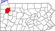 | |
| Boroughs | ||
| Townships | ||
| CDPs | ||
| Unincorporated communities | ||
| Ghost town | ||
| Footnotes | ‡This populated place also has portions in an adjacent county or counties | |